Wintry Precipitation
Winter Storms: Large-Scale Patterns ❄ Wintry Precipitation ❄ Notable Storms ❄ Climate Change ❄ Storm Database ❄ Latest Events
If all of the needed patterns are in place and a wintry event is on the way, then what exactly will we get? During most events, the answer is a little bit of everything, as some parts of the state can see all snow, while others may only receive rain, and in between, there is typically a changeover, often including sleet and freezing rain.
From powdery flakes to dreary raindrops, here’s an overview of the different precipitation types we can see in North Carolina.
Precipitation Types
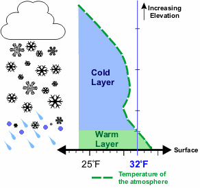
In North Carolina, our wintry precipitation is rarely as simple as rain or snow. Interactions between surface-level cold air and warm air in the mid-levels of the atmosphere tend to make our precipitation types run the gamut during any given wintry event.
Snow
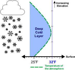
If the entire atmosphere — from the ground level all the way up into the clouds — is below freezing, precipitation falls as snow. But just as it’s said that no two snowflakes are identical, snow can fall in many different forms, depending on the temperature and moisture content of the air.
When it’s colder and drier, we see well-defined snowflakes, often as six-pointed dendrites or hexagonal plates. In developing these lattice-like crystals, Mother Nature makes good use of her available resources, so a little liquid goes a long way. During these sorts of snow events, we can see liquid equivalencies of 20-to-1 or greater, meaning that a melted liquid accumulation 1 inch deep could produce snow 20 inches deep.
More commonly, enough moisture is present aloft that falling flakes will stick together or accumulate droplets on their surface. However, if a relatively deep layer is below freezing, they will still reach the ground as recognizable snowflakes, typically at around a 10-to-1 snow-to-liquid ratio. This is the best snow for would-be builders to work with, as it’s not too fine and powdery but not too slushy either.
During many of our snow events in North Carolina, the air temperature is hovering near freezing and the atmosphere is near full saturation thanks to the moisture flowing in off the Atlantic. In these cases, moisture and falling flakes stick together, which creates the phenomenon of big, wet snowflakes. Unfortunately, these use lots of moisture, so their liquid equivalencies are low: generally around 8-to-1, meaning 1 inch of melted liquid would only produce 8 inches of snow.
And when snowflakes are mixed with rain – usually indicative of temperatures in the lower atmosphere slightly above 32°F, so some melt while others don’t – liquid equivalencies can fall as low as 4-to-1, producing a very slushy snow.
Sleet
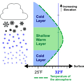
When falling precipitation encounters only a shallow layer of warm air aloft, it may briefly melt from a snowflake into a liquid drop.
Then, as it falls into a deeper layer of cold air near the ground, it has time to refreeze into an ice pellet. This is called sleet.
While sleet sometimes happens at the outset of a wintry event as cold air is building aloft, more often, when you hear its telltale tap-tap-tap sound on your windows, that’s often a warning sign that any snow has ended and ice or rain is on the way with warm air surging in hundreds of feet off the ground.
Significant sleet accumulations are rare, since it usually occurs during the transition between other precipitation types. However, during the winter storm in late January 2010, sleet was a predominant precipitation type across the Piedmont, falling for 15 consecutive hours in Raleigh.
Freezing Rain
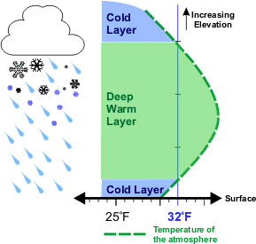
As the mid-levels of the atmosphere warm even more and only a thin layer of cold air is left near the ground, precipitation will melt into a liquid raindrop and never have time to fully refreeze in the air. Instead, when it hits a cold surface — whether that’s a bridge, a branch, or a building — it will freeze on contact, hence the term “freezing rain”.
As North Carolina has experienced plenty of times in the past, a little bit of ice accumulation can cause a lot of damage. The weight of ice a quarter-inch thick is often enough to snap tree limbs, and when they come crashing down, they can damage homes and topple power lines.
If there’s any good news about freezing rain, it’s that it tends to be a self-limiting process. In the act of freezing, heat is extracted from the liquid in the process of becoming a solid, and that heat energy is released into the surrounding air. Eventually, that can bring the entire surface air layer above freezing, although often not before the ice has already done its damage.
Rain
While most aspiring snowflakes leave their clouds with high hopes of being part of your backyard snow sculpture, few will actually realize that dream.
During the majority of our wintertime precipitation events, especially outside of the Mountains, the air near the ground and throughout the lower atmosphere is above freezing, which melts those falling flakes into liquid raindrops.
Of course, rain can be a bummer when we’re eagerly awaiting something frozen, but even on those disappointing winter rain days, we can take solace that precipitation during the winter months is a great deterrent against drought, topping off our lakes and streams and giving farmers ample soil moisture for their springtime planting.
Average Snowfall
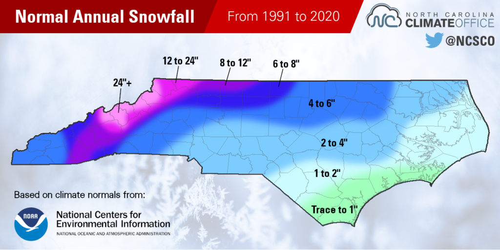
The 1991 to 2020 climate normals, produced by the National Centers for Environmental Information, include 30-year average snowfall amounts for a number of long-term weather observing sites, including in the National Weather Service’s Cooperative Observer program.
These normals show a general pattern of snowfall decreasing from west to east, and from high elevation to low. Our climatological snowiest site in North Carolina, Mount Mitchell, averages 89.1 inches per year, while areas along the coast typically see little to no snow, such as the 0.5-inch average for Morehead City.
The Iciest Areas
During many winter storms, the Piedmont of North Carolina is precariously positioned between cold air to the west and warm air to the east. As the warmer air eventually wins that tug-of-war and only a shallow layer of cold air at the ground level remains, a transition to freezing rain can occur.
Because of the frequency of freezing rain events in this region of the state, the Piedmont — and sometimes, specific areas such as Charlotte or the Triad — have been called the Ice Storm Capital of the South, or even of America.
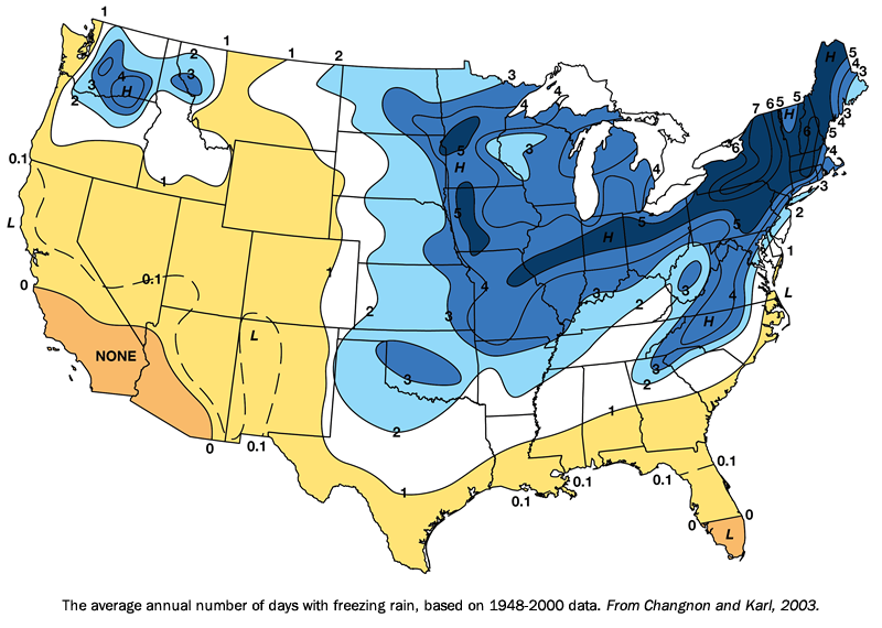
A 2003 study by former Illinois state climatologist Stanley Changnon found that the western Piedmont of North Carolina is indeed the iciest part of the southeastern US, with some areas averaging 4 days per year with freezing rain between 1948 and 2000. However, parts of upstate New York had up to 7 days per year, so we can’t claim to be the national leader.
The Piedmont isn’t the only part of the state that can see impactful ice accumulations, either. The southern Mountains and Foothills had a devastating ice storm in December 2005. The Sandhills had a quarter-inch of ice that caused more than a quarter-million power outages in January 2022. And our southern Coastal Plain has had damaging ice storms in 2014 and 2022.
Event Timing
Accumulating snow is technically possible any time between our first fall freeze, which typically happens in late October or November, and our last spring freeze, which is usually in late March or April.
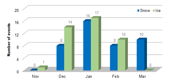
Historically, both snow and ice storms have been most common in January. Climatologically, that is our coldest month of the year, and in North Carolina, a degree or two cooler temperatures can sometimes make the difference between rain and snow.
Major winter storms have happened some with some regularity between December and March. In fact, in our analysis of winter storms between 1959 and 2013, March was the second-most common month for major snow events outside of the Mountains.
The earliest measurable snow event across the Piedmont happened on November 12, 1968. The latest snow in a season for areas such as Boone and Raleigh was on April 18, 1983.