Winter Storm Event
|
Snow, Sleet, Freezing Rain
Started: February 12, 2014 at 1 am EST Ended: February 13, 2014 at 4 pm EST |
|||
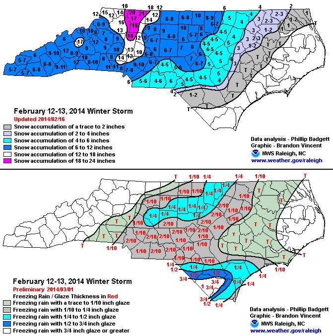
| A classical cold air damming set up provided ample cold and dry air for central North Carolina. As low pressure tracked northeastward from the Gulf of Mexico to just off the Carolina coast, a major winter storm impacted the area. The precipitation started out as all snow across the entire area, but gradually transitioned to a snow/sleet mix and eventually mostly freezing rain across portions of the forecast area as a warm nose overspread portions of the region. Locations in the far northwestern portion of the forecast area stayed mostly all snow and received totals of 6-8 inches, with isolated amounts up to 10 inches. Snow amounts decreased further south and east as there was more mixed precipitation, but nevertheless everywhere in the Piedmont saw at least 3-5 inches of snow/sleet. In addition, everywhere received at least a trace of freezing, with the Interstate 85 corridor receiving around a quarter inch of freezing rain. This resulted in some sporadic power outages and downed trees. | |||
| More Details: | SCO Blog Post Summary | ||
| Injuries | not available | Deaths | not available |
| Property Damage | not available | Crop Damage | not available |
| Atmospheric Maps | Large-scale maps of 500 mb Heights, Jet Stream Winds, and Sea Level Pressure from this event | ||
| Event Analysis from the National Weather Service in Raleigh | |||
 |
|||
| Weather Station Data
Snow Sleet Freezing Rain Rain Mix |
|||
|
|
|||
Back to the Winter Storm Database main page