Winter Storm Event
|
Heavy Snow, Sleet, Freezing Rain
Started: January 29, 2010 at 12 pm EST Ended: January 30, 2010 at 3 pm EST |
|||
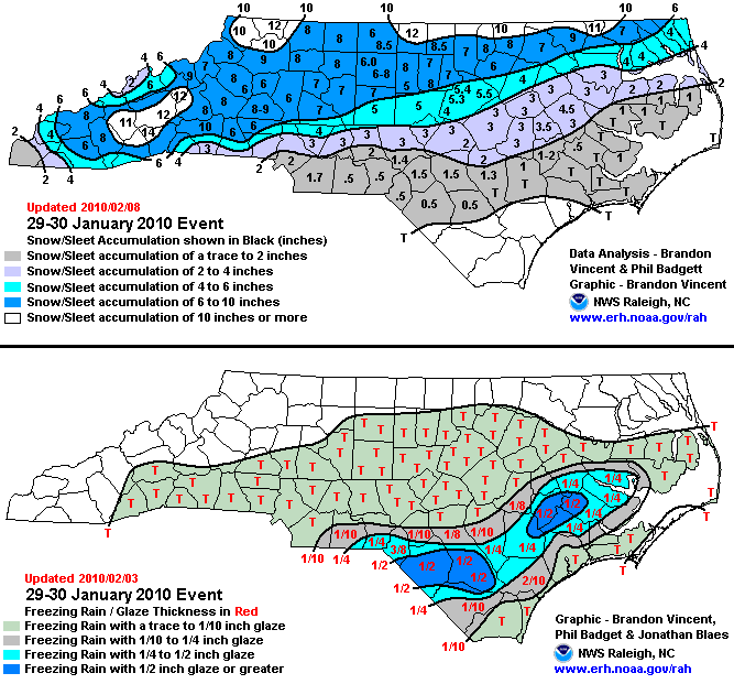
| A strong storm system tracking northeast from the Gulf of Mexico spread heavy snow and freezing rain into Central North Carolina the evening of January 29th. The snow continued into the morning hours of January 30th. Between 5 to 10 inches of snow blanketed areas along and north of Highway 64 with up to a foot of snow reported along the Virginia border. Locations across the southern piedmont, southern coastal plain and sandhills experienced a mix of snow and freezing rain. Freezing rain accumulations ranged from one-eighth to a half inch of ice.
EXTENDED ANALYSIS: This winter storm produced a large swath of snow and ice that extended across the southern Rockies into the Southern Plains, Tennessee Valley and eventually the Carolinas and Mid Atlantic. The Raleigh News and Observer reported that there were 1,000 car accidents across the state, some power outages especially in the Southern Piedmont and Mountains, several injuries from car and sledding accidents and one fatality when a pedestrian was killed by snowplow in Wayne County. The event followed a hybrid "Miller Type A/B" surface pattern in which a primary storm system tracks northeastward across the Southeast toward the southern Appalachians with other weak areas of low pressure or troughs extending north and northeast from the low center. This pattern results in a somewhat complex vertical thermal pattern with broad areas of mixed precipitation. A large swath of 6 to 10 inches of snow with a little sleet fell across northern and western North Carolina with some locations immediately near the Virginia border and in the higher elevations of the mountains receiving around a foot of snow. Further south, 2 to 6 inches of snow and sleet fell along with some freezing rain across a good portion of the Piedmont including the Triangle and Charlotte metro areas. Nearly 1 to 2 inches of sleet were observed in central North Carolina which led to reduced snow accumulations but increased longevity of the snow cover. Around an inch of sleet with a little snow and up to a quarter of an inch of freezing rain fell across portions of the southern Piedmont, Sandhills, southern Coastal Plain and central coastal region. Much of the precipitation on the 29th fell as snow in Greensboro (KGSO), Raleigh (KRDU), and the NWS office in Raleigh (KRAH). On the 30th, sleet mixed in with the snow during the early morning hours. Most of the precipitation in Raleigh fell as sleet after 4:00 AM while in Greensboro, the snow changed to mainly sleet after 9:00 AM. |
|||
| NWS Summary | Case Study from the NWS Raleigh | ||
| Injuries | not available | Deaths | not available |
| Property Damage | not available | Crop Damage | not available |
| Atmospheric Maps | Large-scale maps of 500 mb Heights, Jet Stream Winds, and Sea Level Pressure from this event | ||
| Event Analysis from the National Weather Service in Raleigh | |||
 |
|||
| Weather Station Data
Snow Sleet Freezing Rain Rain Mix |
|||
|
|
|||
Back to the Winter Storm Database main page