Climate Change and Winter Weather
Winter Storms: Large-Scale Patterns ❄ Wintry Precipitation ❄ Notable Storms ❄ Climate Change ❄ Storm Database ❄ Latest Events
Anyone who grew up during the 1980s or earlier in North Carolina is likely to remember some brutally cold and snowy winters back then. And sure, they walked to school uphill both ways as well. But it’s no exaggeration to say that our winters are milder now than they used to be.
Changes in our wintertime weather conditions are one of the most pronounced impacts of climate change in North Carolina. On this page, we’ll take a closer look at those recent changes and what the future may mean for our winter weather.
Winter Trends
According to data from the National Centers for Environmental Information, for the three-month climatological winter from December through February, the average temperature across North Carolina so far this century (from 2001 to 2023) is 43.0°F, compared to a 20th-century average of 41.2°F – an increase of 1.8°F.
That warming is apparent in both our daytime high and nighttime low temperatures, which show increases of 1.8°F and 1.9°F, respectively, from the 20th-century average to the 21st-century average so far.
Statewide, 6 of our warmest 11 winters on record based on average temperatures have happened since 2011.
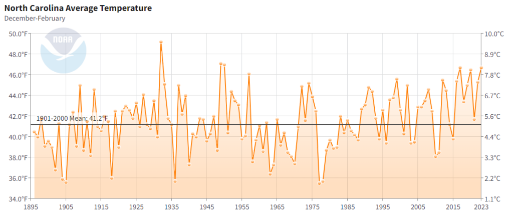
Our Climate Trends Plotter tool shows a statistically significant wintertime warming trend since 1961 at 27 of 28 weather stations in North Carolina with long periods of record and relatively unchanged surroundings over time. Over that 60-year period through 2020, the average warming trend among these stations is +0.71°F per decade.
Average wintertime snowfall amounts have also been trending downward over time. A 2009 study using quality-controlled snow data from across the country found that many areas, including the southern tier from North Carolina through Arizona, saw a reduction in snowfall over the period from 1930 to 2007.
Those trends are especially apparent over the past 40 to 60 years. The 30-year average annual snowfall amounts decreased by more than 50% in some areas between 1961 to 1990 and 1991 to 2020.
| Location | Avg. Annual Snowfall (1961 to 1990) | Avg. Annual Snowfall (1991 to 2020) | Percent Change |
|---|---|---|---|
| Jefferson | 24.2 in. | 12.4 in. | -49% |
| Asheville | 14.0 in. | 10.2 in. | -27% |
| Waynesville | 15.5 in. | 11.5 in. | -26% |
| Charlotte | 7.0 in. | 3.5 in. | -50% |
| Greensboro | 10.3 in. | 7.1 in. | -31% |
| Raleigh | 8.0 in. | 5.1 in. | -36% |
| Fayetteville | 2.1 in. | 0.7 in. | -67% |
| Rocky Mount | 5.1 in. | 1.7 in. | -67% |
| Greenville | 3.4 in. | 3.0 in. | -12% |
| New Bern | 2.9 in. | 0.7 in. | -76% |
| Wilmington | 2.3 in. | 1.0 in. | -57% |
Future Projections
The North Carolina Climate Science Report summarizes the best available science related to climate change and its current and future impacts on our state.
Concerning overall wintertime temperatures, the Climate Science Report notes that:
- “[W]inters have become warmer overall, and that warming is projected to continue. Thus, it is likely that the number of cold days will eventually decrease.”
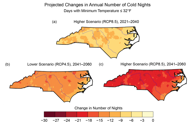
- “The number of cold nights (minimum temperature of 32°F or lower), which are more common in all regions, is projected to decrease significantly across the entire state. By 2021-2040, decreases of 6 to 12 cold nights per year are projected across all three regions of North Carolina, with the Coastal Plain seeing the smallest changes. By 2041-2060, decreases of 12 cold nights or more per year are projected across the majority of the state under the lower [emissions] scenario, and decreases of 18 or more are expected under the higher scenario.”
This warming is expected to continue reducing our snowfall amounts and making all-snow events less frequent:
- “The Fourth National Climate Assessment projects large winter warming under both moderate and higher emissions scenarios. Consistent with the projected warming, a northward shift in the rain-snow transition zone in the central and eastern United States is projected under a higher emissions scenario. By the end of this century, large areas that are currently snow dominated in the cold season are expected to be rain dominated.”
- “For North Carolina, the frequency of snowfall is projected to decrease by the end of this century and become a rare occurrence except in the Western Mountains. Even in the mountains, the frequency of snowfall is projected to decrease substantially, with snowfall increasingly confined to the higher elevations.”
Confidence is lower concerning the overall frequency of coastal low pressure systems such as Nor’easters and the potential for future ice storms in North Carolina. While each of these could increase due to warming in the oceans and atmosphere, they are also subject to complex local atmospheric dynamics.
The bottom line is that our winters are expected to continue warming, with fewer snow events in North Carolina due to climate change.