Winter Storm Event
|
Freezing Rain
Started: January 13, 2015 at 6 pm EST Ended: January 14, 2015 at 11 am EST |
|||
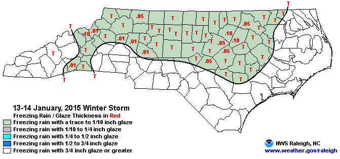
| Mountains:
Light freezing rain and drizzle developed first across the northern mountains during the evening of the 13th, then gradually spread south along the Blue Ridge and east along the I-40 corridor through the overnight and early morning of the 14th. While accumulations were very light, generally no more than a few hundredths of an inch, some secondary roads and bridges and overpasses became slick and hazardous, resulting in a few accidents. Piedmont: Patchy light freezing rain began during the late evening hours on the 13th and continued overnight before ending as freezing drizzle through the late morning hours on the 14th. Ice amounts ranged from a trace to a tenth of inch in a few spots with light glazing on elevated surfaces. A thin glaze of ice was reported on trees and elevated surfaces. Icy bridges and overpasses created difficult travel conditions during the morning on the 14th, with numerous automobile accidents reported throughout the county. |
|||
| Injuries | not available | Deaths | not available |
| Property Damage | not available | Crop Damage | not available |
| Event Analysis from the National Weather Service in Raleigh | |||
 |
|||
| Weather Station Data
Snow Sleet Freezing Rain Rain Mix |
|||
|
|
|||
Back to the Winter Storm Database main page