Winter Storm Event
|
Snow, Freezing Rain
Started: February 23, 2015 at 7 pm EST Ended: February 24, 2015 at 8 pm EST |
|||
| Mountains:
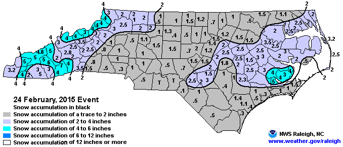
Light snow associated with a wave of low pressure overspread the southern Appalachians by late evening of the 23rd, and continued into the overnight. Snow, heavy at times, continued into the pre-dawn hours, when heavy snow accumulations were reported across much of the area. Total accumulations were generally in the 3 to 5 inch range, with locally higher amounts reported in the high elevations. The snow tapered off shortly after sunrise. Piedmont: An upper level disturbance moving east across the southeast US, caused a low pressure system to develop off the southeast coast. With very cold air in place over the region, as this low tracked northeast, snow developed across the area. With a winter weather advisory in place, most of central North Carolina received 1-2 inches of snow. Coastal Plain: Low pressure moved south of Eastern NC while arctic high pressure to the north supplied cold air to the region. The low pressure system caused a wintry mix of precipitation across the area throughout the day, with mainly snow as the precipitation broke out during the morning. A warm front lifted northward through the day, causing snow to change to freezing rain and sleet from south to north. Snow totals ranged from 2 to 4 inches for a large area of east central NC, with around 1 inch of sleet and snow to the south, including the Crystal Coast. The precipitation changed to a period of freezing rain and sleet across the area by mid afternoon before ending around mid evening. |
|||
| Injuries | not available | Deaths | not available |
| Property Damage | not available | Crop Damage | not available |
| Event Analysis from the National Weather Service in Raleigh | |||
 |
|||
| Weather Station Data
Snow Sleet Freezing Rain Rain Mix |
|||
|
|
|||
Back to the Winter Storm Database main page