Winter Storm Event
|
Snow
Started: February 18, 2015 at 1 pm EST Ended: February 19, 2015 at 3 am EST |
|||
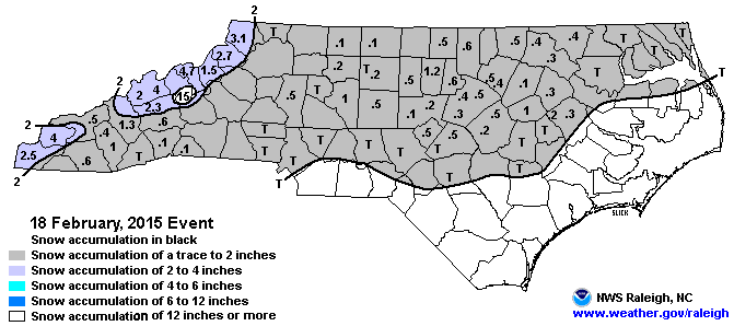
| Snow showers developed across the Southern Appalachians along and immediately behind a strong arctic cold front that swept across the region during the afternoon of the 18th. Snow tapered off in most areas through the evening, the only exception being locations across the far western North Carolina mountains, where snow showers didn't taper off until the pre-dawn hours of the 19th. Total accumulations ranged from a dusting up to an inch in locations closer to the South Carolina border and the lower valleys surrounding the Smokies, to 2-4 inches in the valleys north of I-40 near the Tennessee border. Locally, much higher amounts occurred across the high peaks and ridge tops near the Tennessee border. Combined with the snowfall from the storm of the 16th/17th, areas above 5000 feet reported 1-2 feet of snow on the ground by the morning of the 19th. Very strong winds resulted in considerable blowing and drifting of snow and periods of blizzard-like conditions across these high elevations.
Outside of the mountains, much of the Piedmont and northern Coastal Plain received a dusting of snow with totals of up to 1.2 inches in Burlington. |
|||
| Injuries | not available | Deaths | not available |
| Property Damage | not available | Crop Damage | not available |
| Event Analysis from the National Weather Service in Raleigh | |||
 |
|||
| Weather Station Data
Snow Sleet Freezing Rain Rain Mix |
|||
|
|
|||
Back to the Winter Storm Database main page