Winter Storm Event
|
Snow, Freezing Rain
Started: February 11, 2014 at 9 am EST Ended: February 11, 2014 at 5 pm EST |
|||
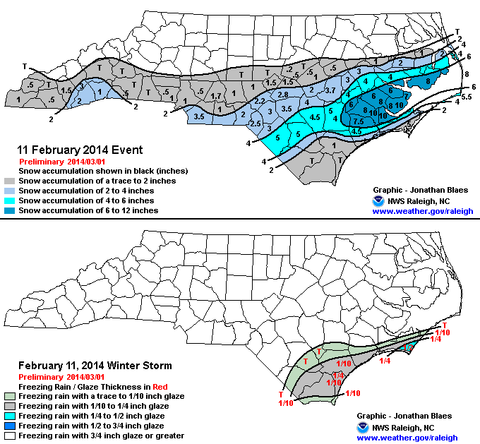
| Ahead of the most significant winter storm of the season, a lead shortwave induced cyclongensis along a stalled surface boundary located across central South Carolina and Georgia. As the low tracked northeastward, snow spread across southeastern North Carolina. Three to four inches ended up falling across Scotland, Hoke, Cumberland, Sampson and Wayne counties. Amounts quickly dropped off further north and west, with a trace to 2-3 inches falling as far north as the US Highway 64 corridor and nothing elsewhere.
Up to a half inch of ice accretion was reported along the Crystal Coast and southern Onslow County as a warm nose aloft was present here. To the north, all snow was reported, with a mesoscale snow band producing a corridor of 8-10 inches of snow from Jones County to central Outer Banks Dare County. Roads became snow and ice covered, and travel became treacherous through the day Tuesday. Precipitation came to an end Tuesday night, though temperatures remained well below freezing with roadways remaining treacherous. |
|||
| Injuries | not available | Deaths | 1 |
| Property Damage | not available | Crop Damage | not available |
| Event Analysis from the National Weather Service in Raleigh | |||
 |
|||
| Weather Station Data
Snow Sleet Freezing Rain Rain Mix |
|||
|
|
|||
Back to the Winter Storm Database main page