Winter Storm Event
|
Snow, Sleet, Freezing Rain
Started: January 28, 2014 at 8 am EST Ended: January 29, 2014 at 8 am EST |
|||
| A low pressure system passed up the Atlantic coast, radiating moisture inland which was forced into the mountains. Canadian high pressure wedged along the eastern face of the Appalachian chain kept temperatures cold enough that the moisture precipitated in the form of snow across the mid-Atlantic region. In many areas, especially those east of the Blue Ridge, this snowfall amounted to the first significant snow accumulations of the winter season.
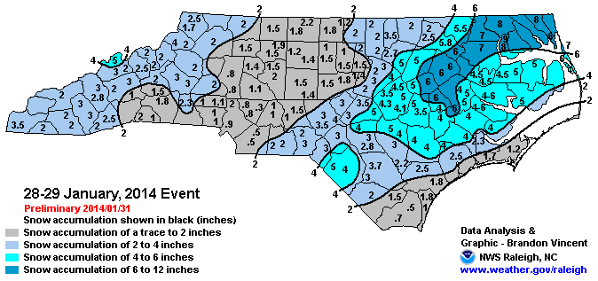
Besides a brief period of sleet in the extreme southeastern portions of the forecast area, only snow was reported across the region. As is typical with a coastal low, the highest snowfall amounts were across the eastern counties, where widespread 4-6 inches of snow fell. Amounts of 2-4 inches were reported across the Triangle, with more in the way of 1-2 inches further west across the Triad. |
|||
| More Details: | SCO Blog Post Summary | ||
| Injuries | 4 | Deaths | 1 |
| Property Damage | not available | Crop Damage | not available |
| Atmospheric Maps | Large-scale maps of 500 mb Heights, Jet Stream Winds, and Sea Level Pressure from this event | ||
| Event Analysis from the National Weather Service in Raleigh | |||
 |
|||
| Weather Station Data
Snow Sleet Freezing Rain Rain Mix |
|||
|
|
|||
Back to the Winter Storm Database main page