Winter Storm Event
|
Snow
Started: February 16, 2013 at 6 am EST Ended: February 17, 2013 at 2 am EST |
|||
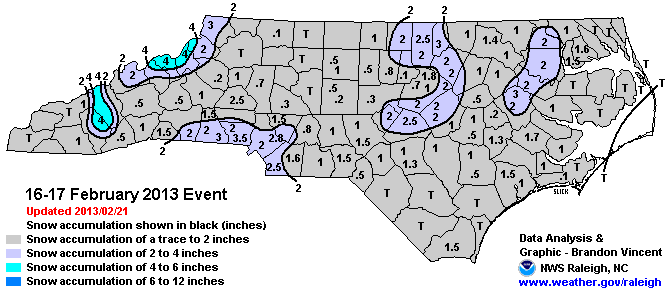
| Much of the state received light snow accumulations as a cold front brought a narrow band of precipitation across the mountains. Most locations in the Piedmont saw temperatures hovering at or just above freezing for the duration of the event, with precipitation beginning as light rain before transitioning to snow. Although the heaviest precipitation was short-lived with this moisture-starved system, some parts of the Triangle and Metrolina did see moderate snow rates for a few hours, resulting in localized accumulations of two to three inches.
Overall impacts were minimal from the event since it occurred on a Saturday and accumulations were generally light. However, for the eastern and southern tiers of the state, this was the most impressive snow event of the entire winter. |
|||
| Injuries | not available | Deaths | not available |
| Property Damage | not available | Crop Damage | not available |
| Atmospheric Maps | Large-scale maps of 500 mb Heights, Jet Stream Winds, and Sea Level Pressure from this event | ||
| Event Analysis from the National Weather Service in Raleigh | |||
 |
|||
| Weather Station Data
Snow Sleet Freezing Rain Rain Mix |
|||
|
|
|||
Back to the Winter Storm Database main page