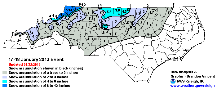
Winter Storm Event
|
Snow
Started: January 17, 2013 at 3 pm EST Ended: January 18, 2013 at 7 am EST |
|||
| A strong 500mb low brought accumulating snow to portions of the North Carolina Piedmont and Mountains in a less-than-ideal setup. Warm antecedent conditions were present ahead of the system -- both air and ground temperatures were in the upper 40s to lower 50s, with widespread rain occurring during the morning and early afternoon of the 17th. However, as the cold pool aloft associated with the upper-level low moved across the region in tandem with intense precipitation rates, a rapid transition from rain to snow occurred from the northwestern mountains all the way to the eastern Piedmont during the late afternoon into the early evening.
Due to the strong dynamics of the system, localized heavy snow bands developed. There were numerous reports of thundersnow across the region, with snowfall rates approaching 2" per hour in the more convective bands. |
|||
| Injuries | not available | Deaths | not available |
| Property Damage | not available | Crop Damage | not available |
| Event Analysis from the National Weather Service in Raleigh | |||
 |
|||
| Weather Station Data
Snow Sleet Freezing Rain Rain Mix |
|||
|
|
|||
Back to the Winter Storm Database main page