Winter Storm Event
|
Heavy Snow, Snow
Started: December 25, 2010 at 12 am EST Ended: December 26, 2010 at 8 pm EST |
|||
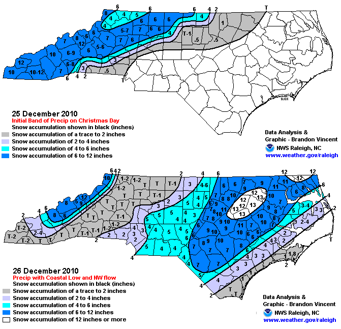
| A powerful winter storm struck North Carolina bringing a prolonged period of heave snow lasting from late Christmas morning through much of December 26th. Eight to fifteen inches of snow blanketed the region and prolonged cold temperatures allows road condition to remain dangerous in some areas for many days. Due to the holiday fewer than normal accidents and injuries were reported.
EXTENDED ANALYSIS: A historic winter storm occurred that produced widespread snow on Christmas Day/Night across the Midwest into the Ohio Valley, Tennessee Valley, the Southeast, Mid Atlantic and eventually the Northeast. In NC, the climatologically less-favored regions of the I-95 corridor saw a large swath of 12"+ accumulations ranging from near Fayetteville to the NC/VA border. The winter storm across central North Carolina is best described by two different mechanisms. The first part of the event produced between 3 and 7 inches of snow across the western and northern potions of the central North Carolina Piedmont during the afternoon and evening of December 25. The second part of the event generally produced between 4 and 12 inches of snow across the eastern Piedmont, the Sandhills and Coastal Plain with the greatest amounts of around a foot falling across the northern coastal plain. This snow was produced by a costal low that developed and then rapidly intensified. As the storm intensified, the rain or the mixed snow and rain changed over to all snow and brought accumulating snow to the eastern two thirds of the state. The event generally followed a "Miller A" surface pattern in which a single well developed low pressure system developed in the Gulf of Mexico and tracked northeast across Florida before moving up the U.S. east coast while rapidly deepening. "Miller A" events typically result in a simpler precipitation pattern that includes corridors of snow and rain with a narrow transition zone in between. This results in a well defined rain-snow line with little or no icing in the narrow transition zone. |
|||
| NWS Summary | Case Study from the NWS Raleigh | ||
| Injuries | 1 | Deaths | not available |
| Property Damage | up to $5,000 | Crop Damage | not available |
| Atmospheric Maps | Large-scale maps of 500 mb Heights, Jet Stream Winds, and Sea Level Pressure from this event | ||
| Event Analysis from the National Weather Service in Raleigh | |||
 |
|||
| Weather Station Data
Snow Sleet Freezing Rain Rain Mix |
|||
|
|
|||
Back to the Winter Storm Database main page