Winter Storm Event
|
Heavy Snow, Snow
Started: March 2, 2010 at 5 am EST Ended: March 3, 2010 at 10 am EST |
|||
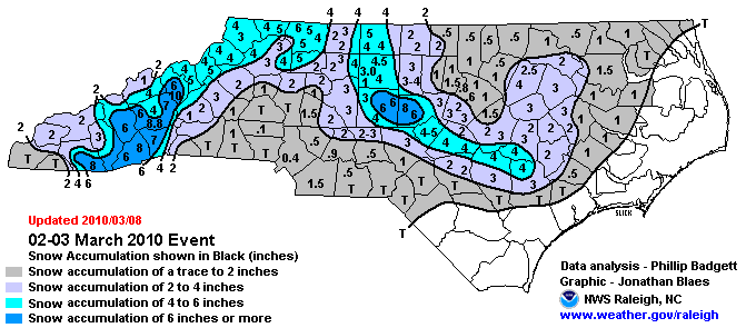
| Low pressure moving off the coastal Carolinas produced between one and two inches of snow across portions of northeast North Carolina from Tuesday night, March 2nd, through Wednesday morning March 3rd.
EXTENDED ANALYSIS: The final major winter storm of the 2009-2010 winter season to affect North Carolina left islands of heavy snow, surrounded by areas with very little snowfall. Like many storms before it, this system tracked out of the Gulf and up the Atlantic seaboard, rapidly deepening over the Gulf Stream offshore of the Carolinas. The "Miller Type A" low pressure system rapidly strengthened offshore the Carolina coast, developing into a 983mb storm as it pulled away from North Carolina on the 3rd. Initially, southwestern portions of North Carolina, including Asheville, experienced significant upslope snow on the order of 6 to 10 inches. As the system transitioned eastward before departing, a significant mesoscale deformation snow band congealed over portions of central North Carolina, with snow rates of up to two inches an hour reported in Lee and Chatham County. The areas under the deformation band for the longest saw as much as 6 to 8 inches of snow, while areas around it saw 2 to 5 inches. Elsewhere, only light amounts of snow were reported. |
|||
| NWS Summary | Case Study from the NWS Raleigh | ||
| Injuries | not available | Deaths | not available |
| Property Damage | up to $2,000 | Crop Damage | not available |
| Atmospheric Maps | Large-scale maps of 500 mb Heights, Jet Stream Winds, and Sea Level Pressure from this event | ||
| Event Analysis from the National Weather Service in Raleigh | |||
 |
|||
| Weather Station Data
Snow Sleet Freezing Rain Rain Mix |
|||
|
|
|||
Back to the Winter Storm Database main page