Winter Storm Event
|
Heavy Snow, Snow
Started: February 12, 2010 at 3 pm EST Ended: February 13, 2010 at 1 pm EST |
|||
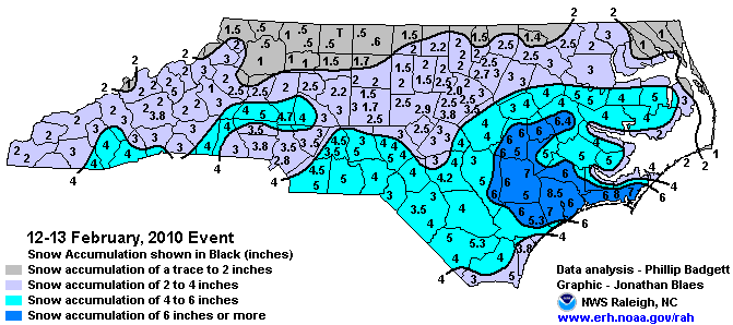
| A rapidly moving coastal storm system along the North Carolina coast produced up to 4 to 5 inches of snow in the Coastal Plain, Sandhills and Piedmont. Around 2 to 3 inches of snow fell across the Northwest Piedmont and Triad. Due the weekend timing of the storm and lack of freezing rain impacts were minimal outside of a number of vehicle accidents.
EXTENDED ANALYSIS: The El Nino-induced active subtropical jet stream produced yet another Gulf of Mexico low pressure system that traveled up the east coast, and with cold air in place in response to a persistently negative NAO, North Carolina experienced yet another winter storm. Following the trend of prior storms, this was a single, well-defined low pressure system (Miller Type A). However, this particular storm did not track as close to the coast as most of the storms during the 2009-2010 winter season did. The storm underwent rapid intensification off the Carolina coast, as northern and southern stream upper level energy phased, which caused the system to deepen to around 986mb by early on the 13th. The result of this intense, rapid deepening and further offshore track was mesoscale snow bands over the southeastern Coastal Plain, where the heaviest snowfall fell. Most of western and central NC saw only light snowfall on the order of 1 to 3 inches due to the offshore track of the low. Meanwhile, the Coastal Plain and southern Piedmont received 4 to 6 inches, while the southeastern Coastal Plain saw generally 5 to 7 inches with a few higher amounts including an 8.5 inch report from Jacksonville in Onslow County. Areas immediately along the southeastern NC coast, including Wilmington, saw slightly lower totals due to a later transition from rain to snow, with most coastal areas reporting 3 to 5 inches of accumulation. |
|||
| Injuries | not available | Deaths | not available |
| Property Damage | not available | Crop Damage | not available |
| Atmospheric Maps | Large-scale maps of 500 mb Heights, Jet Stream Winds, and Sea Level Pressure from this event | ||
| Event Analysis from the National Weather Service in Raleigh | |||
 |
|||
| Weather Station Data
Snow Sleet Freezing Rain Rain Mix |
|||
|
|
|||
Back to the Winter Storm Database main page