Winter Storm Event
|
Heavy Snow, Snow
Started: December 18, 2009 at 6 am EST Ended: December 19, 2009 at 1 pm EST |
|||
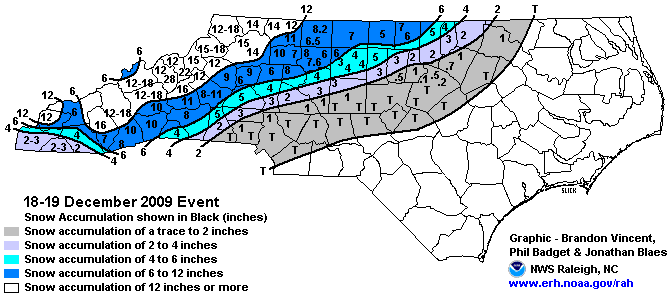
| A strengthening area of low pressure moved out of the Gulf of Mexico, across southern Georgia, and then up the southeast coast. As the low passed south of the region, snow became heavy across the southern and central mountains, as well as the Smokies and surrounding valleys late in the morning. Heavy snow developed a little later over the northern mountains. The heavy snow continued throughout the afternoon. Snowfall rates of 1-2 inches per hour became common across the area during the afternoon. Meanwhile, warming temperatures allowed the snow to mix with and eventually change to rain and sleet in the southwest mountain valleys. The heavy, wet snow combined with gusty winds to cause numerous trees and power lines to fall across the area during the afternoon. Widespread power outages resulted, and some customers were without power for as much as a week. Even longer outages affected parts of the northern mountains. The snow ended over the Blue Ridge and the central mountains on the evening of the 18th. However, wrap around snow showers developed along the Tennessee line, resulting in additional snow accumulations overnight and into the morning hours of the 19th. Total accumulations ranged from 12-18 inches across the lower northern mountain valleys, to 2-3 feet in the higher elevations along the Tennessee border, and in areas along the eastern escarpment. Over the southern and central mountains, total accumulations ranged from 6-10 inches in the lower elevations near the southern escarpment, to as much as 2 feet in the higher elevations. While the southwest mountain valleys generally saw only 3-5 inches, 2-3 feet of total snowfall was reported in the higher elevations of the Smokies and along the Cherohala Skyway in Graham County. Hundreds of traffic accidents were reported during the storm, and continued for several days thereafter, as continuous melting and refreezing of ice and snow resulted in treacherous road conditions during the late night and morning hours. Hospitals reported 100s of cases and slips and falls during this time as well.
EXTENDED ANALYSIS: This winter storm produced a large area of heavy snow just north and west of the NWS Raleigh forecast area with 12 to 24 inches of snow reported across much of the Mid Atlantic and Northeast including many of the major cities along the East Coast. Record breaking snow was observed in several locations including Washington D.C. The event followed the "Miller Type A" surface pattern conceptual model which is characterized by a relatively simple mean sea level pressure pattern where one relatively well organized surface low tracks northeastward with a surface high pressure center located to the north. The "Miller Type A" pattern typically features a well established narrow transition zone of mixed precipitation accompanied by little or no icing. Snow accumulations across North Carolina were stratified from northwest to southeast consistent with the "Miller Type A" pattern. Over a foot of snow fell in many of the mountain locations with 6 to 12 inches of snow in the Foothills. An average of 2 to 6 inches of snow fell in the western and far northern portions of the Piedmont, mainly north and west of Interstate 85. Snow accumulations quickly diminished further east with just a trace to an inch or two of snow across the eastern and southern Piedmont. Accumulations of sleet were fairly light, generally less than a quarter of an inch on top of the snow. Accumulations of freezing rain ranged from a trace up to 1/10 of an inch, mainly across the western and northern Piedmont. |
|||
| NWS Summary | Case Study from the NWS Raleigh | ||
| Injuries | not available | Deaths | not available |
| Property Damage | not available | Crop Damage | not available |
| Atmospheric Maps | Large-scale maps of 500 mb Heights, Jet Stream Winds, and Sea Level Pressure from this event | ||
| Event Analysis from the National Weather Service in Raleigh | |||
 |
|||
| Weather Station Data
Snow Sleet Freezing Rain Rain Mix |
|||
|
|
|||
Back to the Winter Storm Database main page