Winter Storm Event
|
Snow
Started: February 13, 2008 at 7 pm EST Ended: February 14, 2008 at 1 am EST |
|||
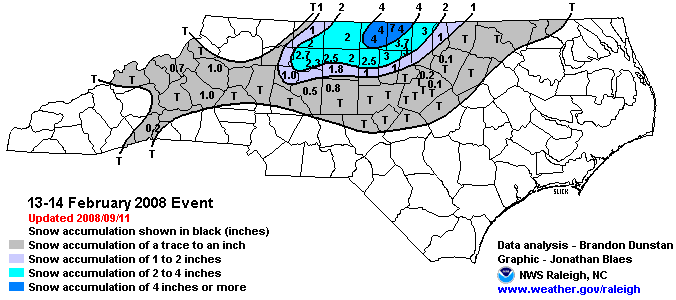
| On February 12th, there was a deep upper-level trough across the eastern U.S. A surface low was lifting northeast toward the Great Lakes. A second surface low developed along an air mass boundary over the Carolinas and tracked north along a coastal warm front. Heavy rain developed over the North Carolina Coastal Plain as the low moved northward, with some locations receiving up to 2 inches of rain. A shortwave trough moved into the area on the evening of the 13th sparking showers and a few thunderstorms over upstate South Carolina and southwestern North Carolina. Much colder and drier air was transported into the Appalachian Mountains and Western Piedmont during the evening hours. As the atmosphere cooled, the rain showers changed to snow, and snow showers, with a few embedded stronger bands developed and moved across the Triad and the Northern Piedmont. The change in weather conditions was dramatic. At 4:00 pm on the 13th, Winston-Salem reported cloudy skies and 50 degrees, just four hours later, it was snowing and 33 degrees. The result was a notable accumulation of snow with many locations receiving at least two inches of snow and a few locations across Person and Caswell Counties receiving as much as 4 to 5 inches of snow. | |||
| NWS Summary | Case Study from the NWS Raleigh | ||
| Injuries | not available | Deaths | not available |
| Property Damage | not available | Crop Damage | not available |
| Event Analysis from the National Weather Service in Raleigh | |||
 |
|||
| Weather Station Data
Snow Sleet Freezing Rain Rain Mix |
|||
|
|
|||
Back to the Winter Storm Database main page