Winter Storm Event
|
Snow
Started: March 1, 2009 at 1 pm EST Ended: March 2, 2009 at 10 am EST |
|||
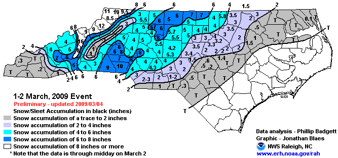
| Rain changed to snow during the early evening across portions of the foothills and the western Piedmont of North Carolina. Snow became heavy at times throughout the evening, and up to 4 inches had accumulated across the area by 10 pm. Snow, heavy at times and accompanied by occasional lightning, continued into the late evening and early overnight hours. By the time the snow tapered off, accumulations of 3-6 inches were common across the area. However, localized amounts of up to 9 inches were reported, especially along a corridor extending from Shelby to Hickory. The heavy wet snow caused quite a few trees and power lines to fall, resulting in numerous power outages. Some structures received minor to moderate roof damage due to the weight of the snow. Some customers were without power for several days. A tree fell on the library in Belmont, NC, causing damage to the roof. Numerous traffic accidents also occurred.
EXTENDED ANALYSIS: Snow accumulations were generally stratified from northwest to southeast primarily because of the temperature distribution in the lower portions of the atmosphere and the placement of the greatest forcing for ascent. Outside of the mountains where 12 inches or more of snow was reported, the heaviest snowfall amounts of 6-10 inches fell in a discontinuous band running from west of Charlotte to west of Greensboro. An average of 2 to 4 inches of snow fell across the eastern portions of the Piedmont and an inch or less fell in the Coastal Plain. Across central North Carolina, the greatest snowfall reports were of 7 inches in Person County. Snow accumulations generally decreased from west to east with 4-6 inches of snow in the Triad, 2-4 inches along the U.S. Highway 1 corridor and a Trace to 2 inches falling along the I-95 corridor. Officially, the RDU airport measured 3.2 inches of snow and Greensboro had 5.7 inches. |
|||
| NWS Summary | Case Study from the NWS Raleigh | ||
| Injuries | not available | Deaths | not available |
| Property Damage | not available | Crop Damage | not available |
| Atmospheric Maps | Large-scale maps of 500 mb Heights, Jet Stream Winds, and Sea Level Pressure from this event | ||
| Event Analysis from the National Weather Service in Raleigh | |||
 |
|||
| Weather Station Data
Snow Sleet Freezing Rain Rain Mix |
|||
|
|
|||
Back to the Winter Storm Database main page