Winter Storm Event
|
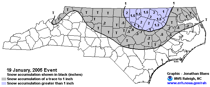
Snow
Started: January 19, 2005 at 9 am EST Ended: January 19, 2005 at 7 pm EST |
|||
| There was a mass exodus of schools and businesses during the early afternoon hours of Wednesday January 19th, 2005. What was a surprise is how quickly and efficiently a light coating of snow on roads became so icy and slick. The mass exodus of many vehicles at nearly the same time clogged the primary roads. Road surface temperatures were too cold to promote melting. Instead, the snail paced traffic compressed the light snow while the heat from vehicular exhausts produce a slight melting effect. The combination of compression and slight melting changed the snow to an icy composition which the cold air temperatures maintained. Numerous accidents on the now slick roads prevented highway crews from spreading salt and sand on the gridlock primary roads. Many school buses were unable to make their rounds, while parents stuck in traffic were unable to get to the schools. What is normally a commuting trip consisting of just tens of minutes turned into an eight hour ordeal. Unusually cold road surface temperatures, air temperatures in the lower 20s, and a mass exit of traffic from early afternoon closures all resulted in very slick driving conditions, numerous accidents, and traffic jams. | |||
| NWS Summary | Case Study from the NWS Raleigh | ||
| Injuries | not available | Deaths | not available |
| Property Damage | not available | Crop Damage | not available |
| Atmospheric Maps | Large-scale maps of 500 mb Heights, Jet Stream Winds, and Sea Level Pressure from this event | ||
| Event Analysis from the National Weather Service in Raleigh | |||
 |
|||
| Weather Station Data
Snow Sleet Freezing Rain Rain Mix |
|||
|
|
|||
Back to the Winter Storm Database main page