Winter Storm Event
|
Snow, Heavy Snow
Started: January 19, 2009 at 4 pm EST Ended: January 20, 2009 at 11 pm EST |
|||
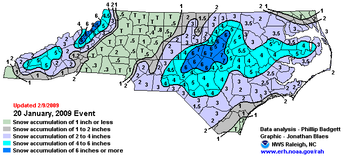
| On January 20, 2009, the first major winter storm to strike central and eastern North Carolina since 2004 brought 3 to 7 inches of snow to most of the area. A strong upper level disturbance dropped quickly southeast into the mid-Atlantic followed by a surface low pressure which developed south of Wilmington. The combination of cold air and moisture surging in from the coast allowed the rain to transition to snow between midnight and 3 am. Snow lasted until afternoon in many locations and did not taper off in the Interstate 95 corridor until 3 pm. | |||
| Injuries | not available | Deaths | not available |
| Property Damage | not available | Crop Damage | not available |
| Atmospheric Maps | Large-scale maps of 500 mb Heights, Jet Stream Winds, and Sea Level Pressure from this event | ||
| Event Analysis from the National Weather Service in Raleigh | |||
 |
|||
| Weather Station Data
Snow Sleet Freezing Rain Rain Mix |
|||
|
|
|||
Back to the Winter Storm Database main page