Winter Storm Event
|
Snow
Started: February 1, 2007 at 6 am EST Ended: February 1, 2007 at 1 pm EST |
|||
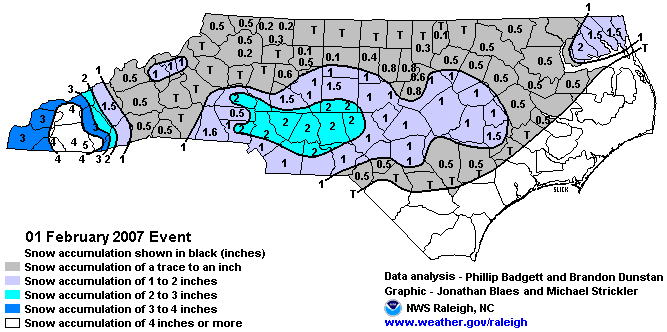
| The combination of moisture streaming in from the south with cold air over Central North Carolina resulted in an early morning snow event for all of Central North Carolina. Light snow began around sunrise across the southern piedmont and foothills of North Carolina. The snow began to mix with and eventually changed over to sleet and freezing rain by late morning. Up to 2 inches of snow, along with light accumulations of sleet and ice occurred before a transition to rain in the early afternoon. Slick roads resulted in quite a few traffic accidents, especially along the I-40 corridor.
By late morning, up to 3 inches of snow had accumulated across the area, while some locations received light accumulations of sleet. A mix of sleet and freezing rain continued across the southern foothills through early afternoon. Meanwhile, up to an eight of an inch of ice and as much as a half inch of sleet had accumulated on top of 2-3 inches of snow. By early afternoon, most of the precipitation had transitioned to rain. Up to 2 inches of snow fell over portions of the piedmont from Albemarle to Lexington and Asheboro. Most other locations picked up around an inch of snow. Even with so little snow, due to the cold ground and timing of the snow during the morning commute the impact on the area was significant. |
|||
| NWS Summary | Case Study from the NWS Raleigh | ||
| Injuries | not available | Deaths | not available |
| Property Damage | not available | Crop Damage | not available |
| Atmospheric Maps | Large-scale maps of 500 mb Heights, Jet Stream Winds, and Sea Level Pressure from this event | ||
| Event Analysis from the National Weather Service in Raleigh | |||
 |
|||
| Weather Station Data
Snow Sleet Freezing Rain Rain Mix |
|||
|
|
|||
Back to the Winter Storm Database main page