Winter Storm Event
|
Snow, Sleet
Started: January 29, 2005 at 3 am EST Ended: January 30, 2005 at 1 pm EST |
|||
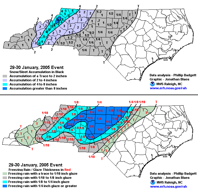
| A low pressure system spread moist air above a cold air mass in place at the surface across southwest North Carolina creating a mixture of freezing rain and sleet over the region. Up to an inch of snow fell across the area during the morning, but sleet and ice made the greatest impact. After 1 to 3 inches of snow fell across the area during the morning and early afternoon, a layer of 1/4 to 1/2 inch of sleet, as well as a thin layer of glaze, accumulated on top of the snow during the afternoon and evening. This created extremely dangerous driving conditions and numerous accidents. The weight of the ice downed trees and power lines.
Light snow developed during the pre-dawn hours across Avery County. By mid-morning, 2 to 3 inches of snow had accumulated, resulting in slick roads and quite a few accidents. This brought a half inch of sleet to the Winston-Salem area. A lull in the precipitation was followed by a period of freezing rain Sunday morning. A quarter inch of ice accrued in the central and western Piedmont, which created icy roads and caused numerous accidents. Ice accretion was one quarter of an inch in most locations with a few isolated locations in Rockingham County receiving one third inch accretion. Snowfall was a secondary element with 3 to 4 inches being the norm. The exception was Ashe County where snowfall amounts ranged from 4 to 5 inches. The most snow fell in Watauga and Avery Counties with accumulations of up to 8 inches of snow. |
|||
| Injuries | not available | Deaths | not available |
| Property Damage | not available | Crop Damage | not available |
| Atmospheric Maps | Large-scale maps of 500 mb Heights, Jet Stream Winds, and Sea Level Pressure from this event | ||
| Event Analysis from the National Weather Service in Raleigh | |||
 |
|||
| Weather Station Data
Snow Sleet Freezing Rain Rain Mix |
|||
|
|
|||
Back to the Winter Storm Database main page