Winter Storm Event
|
Heavy Snow, Sleet
Started: February 26, 2004 at 3 am EST Ended: February 27, 2004 at 6 am EST |
|||
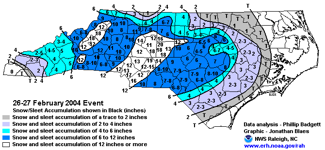
| A strong storm arrived on February 26th and continued into the morning of the 27th. The storm hit the area with a one-two punch, affecting southern sections on the 26th, then northern sections late on the 26th and the 27th.
The first punch dumped heavy snow over portions of the southern Piedmont and Sandhills. Accumulations totaled 6 to locally 10 inches in areas such as Laurinburg, Hamlet, Fayetteville, and Raeford. Much lighter amounts fell to the north during the day. The second punch arrived in western sections of the area late in the day and shifted northeast across central and eastern portions overnight. The heavy snow was accompanied by thunder and lightning across the western Piedmont. Snowfall amounts ranged between 12 and 18 inches from Albemarle northeast to Greensboro. Other sections of the Piedmont, including the Triangle, received between 3 and 6 inches. Heavy snow began to fall across the foothills, piedmont, and northern mountains of North Carolina during the late morning. Although snowfall intensity decreased dramatically during the early-to-middle portion of the afternoon, heavy snow redeveloped during the late afternoon, and continued into the evening and overnight hours. Scattered thunderstorms contributed to intense snowfall rates of 2 to 3 inches per hour from time to time, especially in the piedmont, where total snowfall of 12-22 inches occurred. The heaviest amounts occurred in the southwest piedmont, particularly in southern portions of Charlotte metro. Thousands of people were stranded on I-77 during the early afternoon, and some required rescue. The weight of the snowfall caused damage to numerous roofs, while some roofs completely collapsed. Across the foothills and northern mountains, accumulations were considerably lighter, generally in the 4-8 inch range, although amounts of 10-16 inches fell along the Blue Ridge north of I-40. |
|||
| Injuries | not available | Deaths | not available |
| Property Damage | up to $3,100,000 | Crop Damage | not available |
| Atmospheric Maps | Large-scale maps of 500 mb Heights, Jet Stream Winds, and Sea Level Pressure from this event | ||
| Event Analysis from the National Weather Service in Raleigh | |||
 |
|||
| Weather Station Data
Snow Sleet Freezing Rain Rain Mix |
|||
|
|
|||
Back to the Winter Storm Database main page