Winter Storm Event
|
Snow, Sleet, Freezing Rain
Started: December 4, 2002 at 12 pm EST Ended: December 5, 2002 at 2 pm EST |
|||
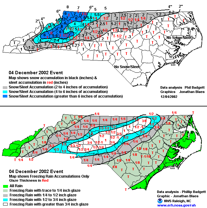
| One of the worst ice storms to ever hit Central North Carolina began in the late afternoon on December 4, and ended in the early morning hours of December 5. Strong high pressure over the mid-Atlantic fed a shallow layer of cold air across interior portions of the state. Low pressure formed over the Gulf coast, spreading moisture over the Carolinas. Precipitation mainly began as a mix of snow and sleet, then turned to freezing rain. A quarter inch of ice or more covered locations mainly to the west of I-95. The highest precipitation amounts stretched across the Piedmont, from Albemarle to Asheboro to Durham to Warrenton, where a half inch to one inch thick layer of ice was reported. 1 to 2 inches of snow also fell in the Triad area and in the counties bordering Virginia with trace amounts elsewhere. Snow began during the early afternoon across the North Carolina foothills and northwest piedmont, and had accumulated to 3 to 5 inches by late evening. Large trees and power lines were downed by the ice all across the area. The storm caused a record number of power outages, as nearly one million people lost power in Central North Carolina, some for nearly a week. | |||
| NWS Summary | Case Study from the NWS Raleigh | ||
| Injuries | not available | Deaths | not available |
| Property Damage | $99,000,000 to $100,000,000 | Crop Damage | not available |
| Atmospheric Maps | Large-scale maps of 500 mb Heights, Jet Stream Winds, and Sea Level Pressure from this event | ||
| Event Analysis from the National Weather Service in Raleigh | |||
 |
|||
| Weather Station Data
Snow Sleet Freezing Rain Rain Mix |
|||
|
|
|||
Back to the Winter Storm Database main page