Winter Storm Event
|
Snow, Sleet
Started: January 2, 2002 at 3 pm EST Ended: January 3, 2002 at 11 pm EST |
|||
| Low pressure formed in the Gulf of Mexico the morning of January 2nd and moved up the eastern seaboard. Moisture moved north, overrunning cold high pressure, setting up a wintry mix for North and South Carolina. The precipitation began as snow over South Carolina that afternoon, and expanded to include North Carolina later that afternoon. The precipitation changed to freezing rain and sleet, then to rain over coastal sections of North and South Carolina that evening and continued through the morning of January 3rd. The precipitation in the inland counties remained as a mix of freezing rain and sleet. As the low pressure center continued to track north, cold air wrapped around the system, changing the precipitation back to all snow by midday on January 3rd, and continued until the snow tapered off by early morning on January 4th.
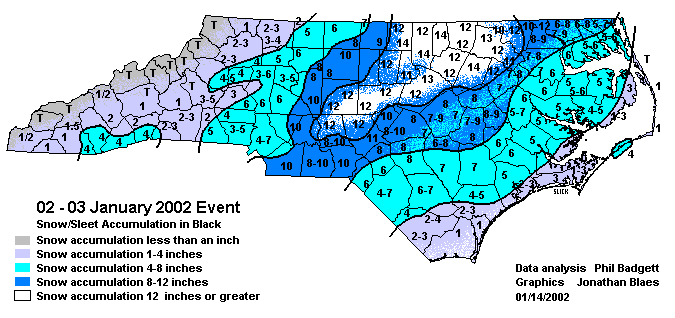
The snowfall totals were heaviest over portions of South Carolina counties Darlington and Marlboro while in nearby Robeson County, North Carolina, 6 to 8 inches fell, with some sleet mixed in. Counties further south and east, including South Carolina: Florence, Marion, Dillon, and North Carolina: Bladen received between 4 and 6 inches of snow, including between a half and an inch of freezing rain and sleet. Along coastal counties, between 1 and 3 inches of snow occurred, with around a half inch of sleet and freezing rain. There were numerous traffic accidents reported, although there was no information on injuries. In Florence County alone, emergency personnel reported 167 accidents, over double the normal amount. There were over 1500 traffic accidents reported in South Carolina alone. The freezing rain from the storm forced many trees and large branches to snap, causing numerous power outages around the area. More than 25,000 customers were without power in South Carolina: Horry and Georgetown and North Carolina: Brunswick County. Secondary roads in most areas proved treacherous, but road crews managed to keep highways and primary roads open. Many businesses and schools were closed on January 3rd and 4th, including 64,000 state workers. Some specific higher snow totals included: Lasker in Northampton county 12.5", Seaboard in Northampton county 9.0", Colerain in Bertie county 8.0", Ahoskie in Hertford county 7.0", Elizabeth City in Pasquotank county 6.5", Windsor in Bertie county 6.0", and Edenton in Chowan county 5.0". Gusty winds of 20 mph on the morning of the 3rd caused numerous trees and power lines to fall casing minor damage and numerous power outages. A second snow event began on the evening of the 3rd and dropped anywhere from 4 to 8 inches of snow across the region. Snowfall rates of over 2 inches per hour were observed in many locations. Two injuries occurred in a head-on collision between two vehicles in Pitt county due to ice covered roads. |
|||
| NWS Summary | Case Study from the NWS Raleigh | ||
| Injuries | 2 | Deaths | not available |
| Property Damage | not available | Crop Damage | not available |
| Atmospheric Maps | Large-scale maps of 500 mb Heights, Jet Stream Winds, and Sea Level Pressure from this event | ||
| Event Analysis from the National Weather Service in Raleigh | |||
 |
|||
| Weather Station Data
Snow Sleet Freezing Rain Rain Mix |
|||
|
|
|||
Back to the Winter Storm Database main page