Winter Storm Event
|
Heavy Snow, Sleet, Wind
Started: March 20, 2001 at 8 am EST Ended: March 21, 2001 at 2 am EST |
|||
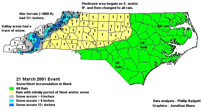
| Low pressure developed off the South Carolina coast and steadily strengthened as it moved northward across the coastal waters of North Carolina, the Virginia tidewater and eventually out to sea. Rapid strengthening occurred as a strong upper level disturbance rotated around an upper low that was crossing the southeast states. As the cyclone strengthened, abundant moisture was wrapped around the storm and thrown back against the higher terrain of the Carolinas, resulting in high winds and very heavy snow.
The heaviest snow accumulations were in far western North Carolina. The highest accumulations were 24 to 30 inches at Sugar Mountain, Beech Mountain and Newland in Avery County, at Mount Mitchell in southern Yancey County and in a narrow swath along the border between Madison and Haywood counties. However, accumulations of over a foot were reported from most mountain counties, including Buncombe, Haywood, Jackson, Macon, Mitchell, and Transylvania. Accumulations of over a foot also extended into the extreme western foothills, where Jonas Ridge and Little Switzerland each recorded between 12 and 16 inches of snow. East of the higher terrain, snowfall amounts ranged from 2 to 5 inches from northern Caldwell county southward to Morganton, Marion, Lake Lure and Tryon. Isolated 2 inch amounts came from as far east as Casar in northern Cleveland County. Wind damage was far more widespread than the heavy snow, for most foothill and piedmont areas experienced numerous downed trees and power lines, although damage appeared to take on a more scattered character as one moved east away from the higher terrain. The highest wind gust was an estimated 80 knots from a cooperative observer at Flat Top Mountain in southeast Buncombe County. Snow from late in the morning of the 20th through the early morning of the 21st accumulated from 5 to 12 inches. In Ashe and Watauga counties, the combination of the heavy wet snow and strong winds downed power lines with scattered power outages reported. In Watauga County there was also minor damage to several structures when trees land on them. High winds In Surry County during the night of the 20th and the morning of the 21st downed trees and power lines. Several trees were downed onto cars. |
|||
| Injuries | not available | Deaths | not available |
| Property Damage | not available | Crop Damage | not available |
| Event Analysis from the National Weather Service in Raleigh | |||
 |
|||
| Weather Station Data
Snow Sleet Freezing Rain Rain Mix |
|||
|
|
|||
Back to the Winter Storm Database main page