Winter Storm Event
|
Snow, Sleet, Freezing Rain
Started: January 28, 2000 at 10 am EST Ended: January 30, 2000 at 6 pm EST |
|||
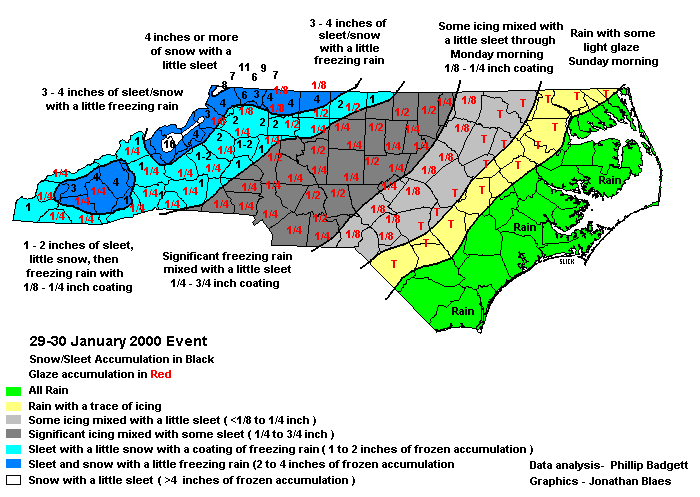
| Weakening low pressure in the Ohio River Valley, developing low pressure along the Gulf Coast and cold, arctic air in place across the Carolinas resulted in a wintry mess across western North Carolina. This was the last in a series of 5 winter storms that wreaked havoc on western North Carolina in an 11 day span. The ice storm in the mountains consisted mainly of a couple inches of sleet. However, the combined accumulation of the mixture of sleet and snow was generally 2 to 3 inches. Some freezing rain mixed in during the morning of the 30th. Across the foothills and piedmont, precipitation which briefly began as some light sleet and snow, turned quickly to freezing rain. The freezing rain was heavy enough across the southern piedmont, including the Charlotte area, to result in a 1/4 to 1/2 inch glaze. Scattered power outages resulted, with Gaston county reporting 2500 people without power. The entire Duke Power system reported 77,000 people without power.
Sleet and freezing rain began to fall in the western Piedmont of North Carolina on the evening of the 28th. The ice accumulated to a half inch in some locations near the Triad area and along the Virginia border, with most locations in the area receiving around a quarter of an inch of ice. The rest of central North Carolina received a thin coating of less than a quarter inch, creating patchy spots of ice on roads and causing downed trees and power lines. Approximately 30,000 people were without power across the state at the peak of the storm. In eastern portions of the Sandhills and in the Coastal Plain, the freezing rain changed to light rain, preventing more widespread icing in that area. A lull in the precipitation from the predawn hours on Sunday until Sunday morning also kept ice accumulation minimal. Snow and sleet accumulations ranged from 1 to 4 inches, then became mainly freezing rain late at night. Glaze accumulated 1/4 inch to 1/2 inch before the freezing rain ended during the afternoon on the 30th. |
|||
| Injuries | not available | Deaths | not available |
| Property Damage | not available | Crop Damage | not available |
| Atmospheric Maps | Large-scale maps of 500 mb Heights, Jet Stream Winds, and Sea Level Pressure from this event | ||
| Event Analysis from the National Weather Service in Raleigh | |||
 |
|||
| Weather Station Data
Snow Sleet Freezing Rain Rain Mix |
|||
|
|
|||
Back to the Winter Storm Database main page