Winter Storm Event
|
Heavy Snow
Started: January 24, 2000 at 5 am EST Ended: January 25, 2000 at 11 pm EST |
|||
| This record-setting snow storm began with freezing drizzle in the early morning hours of the 24th. Low pressure rapidly deepened near the Carolina coast, wrapping abundant moisture back across the piedmont of the Carolinas. Snow fell all day and into the night, heavy at times south and east of Interstate 85. Road surfaces quickly froze during this time when the temperature dropped from 32 degrees to 27 degrees. Numerous traffic accidents were reported. By mid-morning, additional precipitation was advancing northward into the southern portions of central North Carolina. During the afternoon of the 24th, rain was falling across southeastern North Carolina while an area of snow was located over the southwest Piedmont to the western Sandhills. Later that evening the precipitation reached the Triangle area, beginning as mostly sleet before quickly changing to all snow.
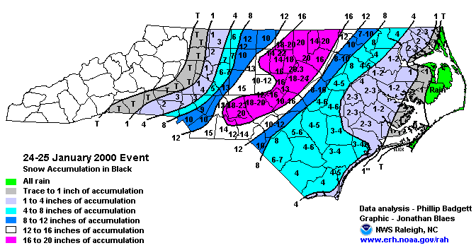
The heavy snow brought central North Carolina to a standstill. Many roads were impassable, and power outages were reported across the entire area. Statewide, an estimated 260,000 people were without power, mostly in the Sandhills. Strong, gusty winds produced snow drifts several feet high. At the Raleigh-Durham Airport, the record snowfall from one storm was set at 20.3 inches. The total cost of the storm to the state was estimated at $800 million. By the time the snow ended, accumulations ranged from a trace to 4 inches to the immediate north and west of Interstate 85, to 4 to 8 inches from eastern Rowan County to Charlotte and Gastonia, and 10 to 14 inches across southeastern Mecklenburg County and all of Union County. Utility damage in Union county alone was above $4 million, with damage in Monroe at more than $1 million. This storm followed no more than 36 hours after the area received several inches of snow and ice from a previous storm over the weekend. Northeastern North Carolina also received significant snowfall amounts: Northampton County saw between 7 and 10 inches. Precipitation actually began as rain, which changed to heavy snow. Snow then mixed with sleet and freezing rain during the day. There was blowing and drifting of snow from winds which gusted over 30 mph at times, creating power outages. This storm dropped between 5 and 6 inches of snow across Bertie County. Also, 3 to 4 inches of snow fell across Hertford County and around 4 inches fell in Gates County. Snow rapidly accumulated 6 to 7 inches deep in Robeson County, and 4 to 6 inches deep across the rest of Southeast North Carolina by sunrise. Specific county accumulations were: Chowan County 3 to 4inches, Perquimans County 2 inches, Pasquotank County 2 to 3 inches, and Camden County 2 to 3 inches. Very cold temperatures built in following the storm system, preserving the snow pack for up to a week. Roads were treacherous and schools and businesses were closed for a couple of days in much of the area. |
|||
| NWS Summary | Case Study from the NWS Raleigh | ||
| Injuries | not available | Deaths | not available |
| Property Damage | not available | Crop Damage | not available |
| Atmospheric Maps | Large-scale maps of 500 mb Heights, Jet Stream Winds, and Sea Level Pressure from this event | ||
| Event Analysis from the National Weather Service in Raleigh | |||
 |
|||
| Weather Station Data
Snow Sleet Freezing Rain Rain Mix |
|||
|
|
|||
Back to the Winter Storm Database main page