Winter Storm Event
|
Blizzard
Started: December 22, 1989 at 9 pm EST Ended: December 24, 1989 at 1 pm EST |
|||
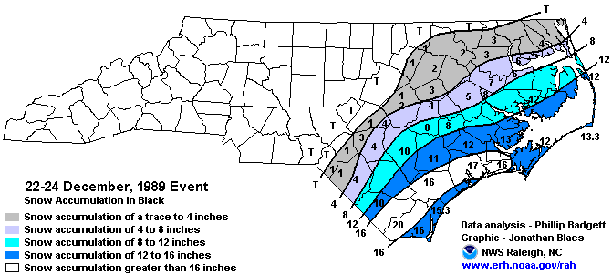
| On the evening of December 22 a developing offshore storm system began to produce snow in southeastern North Carolina. By early on the 23rd, the storm had intensified dramatically, producing 60 mph winds and waves as high as 34 feet in the near-shore waters. The tanker Benjamin Isherwood ran aground just off Corolla. Snow fell from the evening of the 22nd to about midday on the 24th.
Final snow depths were from one to three inches across the Sandhills and Northern Coastal Plain, with four to 12 inches in the Southern and Central Coastal Plain. Up to 15 inches of snow fell in the immediate coastal counties from Cape Hatteras to Cape Lookout. The final snow depth at Cape Hatteras was 13.3 inches. This does not account for about five inches of snow that melted when the snow changed briefly to rain on the 23rd. Along the northern coast, snow amounts ranged from 10 inches at Manteo to one inch at the Virginia border. Gusty winds piled snow drifts four to eight feet high all along the coast. Many towns were paralyzed. The snow shattered most snow records for the area. It was also the first White Christmas on record for coastal North Carolina. Two deaths in Camden County were attributed to the winter weather. An elderly man went outside for kerosene, slipped and fell in a snow bank, was unable to get up, and froze to death. The second death involved an elderly man who died of hypothermia in an unheated home. |
|||
| More Details: | SCO Blog Post Summary | ||
| Injuries | not available | Deaths | 2 |
| Property Damage | not available | Crop Damage | not available |
| Atmospheric Maps | Large-scale maps of 500 mb Heights, Jet Stream Winds, and Sea Level Pressure from this event | ||
| Event Analysis from the National Weather Service in Raleigh | |||
 |
|||
| Weather Station Data
Snow Sleet Freezing Rain Rain Mix |
|||
|
|
|||
Back to the Winter Storm Database main page