Tropical Storm Science
Hurricanes: Tropical Storm Science 🌀 Hazards 🌀 Notable Storms 🌀 Climate Change 🌀 Hurricanes Database 🌀 NC Landfalls
Hurricanes have a beautiful symmetry, with rain bands spiraling around a cloud-free circular eye, that’s a product of their step-by-step development and the scientific processes that drive it. From their formation as atmospheric seedlings to their strengthening at sea to their impacts on our state, science has a lot to say about how these storms work.
Tropical Storm Life Cycle
Tropical storms are atmospheric phenomena that are fueled by the oceans. Throughout their lifetimes, these storms see a close interaction between air and water to help them develop, strengthen, and power their eventual impacts upon reaching land.
Tropical Beginnings
Each storm starts as an atmospheric disturbance, which can take a few different forms:
- Sometimes, these storms can develop from a frontal boundary stalled over the warm water of the Gulf Stream off our east coast.
- Over the warm Caribbean or Gulf of Mexico, a cluster of thunderstorms can likewise become sufficiently organized to become a tropical system.
- Many long-lived storms that cross the Atlantic begin as weak-but-wet low-pressure systems called African easterly waves that form over the African continent before moving across the eastern Atlantic Ocean.
No matter their atmospheric origins, these disturbances need warm water in the ocean beneath them to kickstart their tropical development. Typically, sea surface temperatures of at least 79°F (or 26°C) are needed for tropical storms to form. That water warms the air above it and evaporates to increase the humidity. That warm, moist air then rises in a process called convection, which causes thunderstorms to form and release the latent heat that drives further development.
Storm Strengthening
Once they start forming, these systems need a few other ingredients in place to help and not hinder their development:
- A moist atmosphere provides more fuel for clouds and thunderstorms, while dry air – including from Saharan dust blown across the main development region of the Atlantic – can sap the moisture within a storm.
- Wind shear, or the change in winds with increasing height in the atmosphere, can rip apart the clouds and thunderstorms in and around the developing eye of a tropical storm. Low vertical wind shear, particularly with weaker upper-level wind speeds, gives storms more breathing room for upward development.
- An unstable atmosphere, characterized by warmer air near the surface and cooler air aloft, means that warm and moist air can rise in strong updrafts that help further grow the thunderstorms at the heart of these tropical systems.
If these ingredients come together, the once-disorganized disturbance will coalesce around a thunderstorm-laden core, with outer rain bands rotating around a low-pressure center of circulation.
Classification
As tropical systems become better organized, they can be classified in one of the following ways based on the maximum sustained winds, typically located near the center of circulation or in the eyewall of stronger storms.
- The pressure difference between the heart of these storms and their surrounding environment powers winds that spiral toward the center. Once the maximum sustained winds reach 38 miles per hour, a system is classified as a tropical depression.
- With winds of at least 39 miles per hour, it becomes a tropical storm and is given a name from a regional list curated by the World Meteorological Organization. Storm naming began within the US military to help internal communications about these systems, and it became a public communications tool during the 1950s.
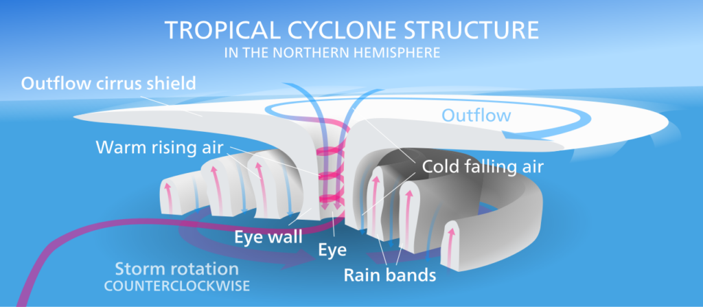
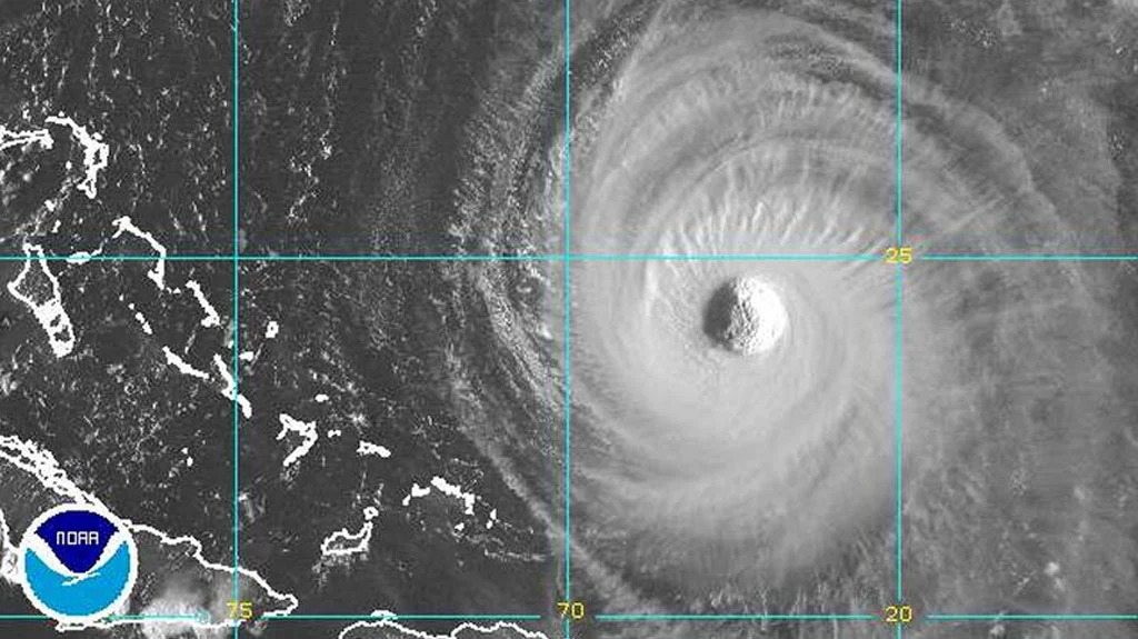
- Once a storm’s sustained winds reach 74 miles per hour or greater, it becomes a hurricane in the north Atlantic basin, with further categorization based on the Saffir-Simpson scale. Hurricanes often feature a classic look with a cloud-free eye ringed by an intense, stormy eyewall and flanked by outer bands. This structure ultimately helps these storms keep their strength, as air circulates from their warm core to the cool upper levels of the atmosphere on their fringes.
Late in Life
While a hurricane can remain active for days or even weeks, they all eventually come to an end through one or more of the following ways:
- The tropical Atlantic offers a 3,000-mile runway of warm ocean water to fuel developing hurricanes, but on the western edge of the ocean are the landmasses of north and central America. When storms move over this land, they’re cut off from their warm water fuel and their winds are weakened by the frictional effects of the rough land surface. This stops their development and causes them to weaken.
- Due to the earth’s rotation, hurricanes naturally curve toward the poles during their lifetimes – a result of the Coriolis effect that causes moving air to deflect to the right in the Northern Hemisphere. As storms move poleward, they eventually move over either land or colder water, which ends their tropical lifespans. In some cases, they can then become extratropical cyclones, which can still pack some high winds and other intense impacts, but that become frontal in nature as the warm-natured storms venturing into colder environments.
- Hurricanes aren’t the only weather systems in the atmosphere; cold fronts and other low-pressure areas are always circulating as well, and when these systems meet, they can interact – sometimes enhancing a tropical storm’s impacts, such as feeding it more moisture as during Tropical Storm Eta in 2020, but eventually eroding a tropical storm’s structure and causing it to lose its tropical characteristics.
Seasonality
The Atlantic hurricane season runs from June through November, but each of those six months has its own unique characteristics in terms of where tropical storms tend to form:
- Early in the season — and sometimes, even in April or May, before hurricane season officially begins – storms are most likely to form where the ocean water is warmest, either in the Gulf of Mexico or over the Gulf Stream current that runs along our east coast.
- By mid-summer, as the rest of the Atlantic’s main development region warms up, storms typically begin developing off the coast of Africa by August, with a “conveyor belt” of disturbances and storms often setting up by the peak of the season in September.
- By late-season in the fall, the still-warm parts of the western Atlantic become the favored regions for any late-season storms, and as the upper-level winds such as the jet streams strengthen, they sometimes push storms from west to east rather than their more common east-to-west trajectories.
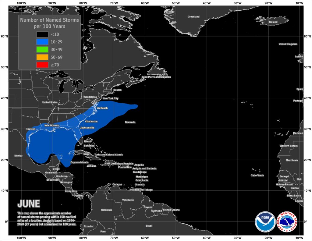
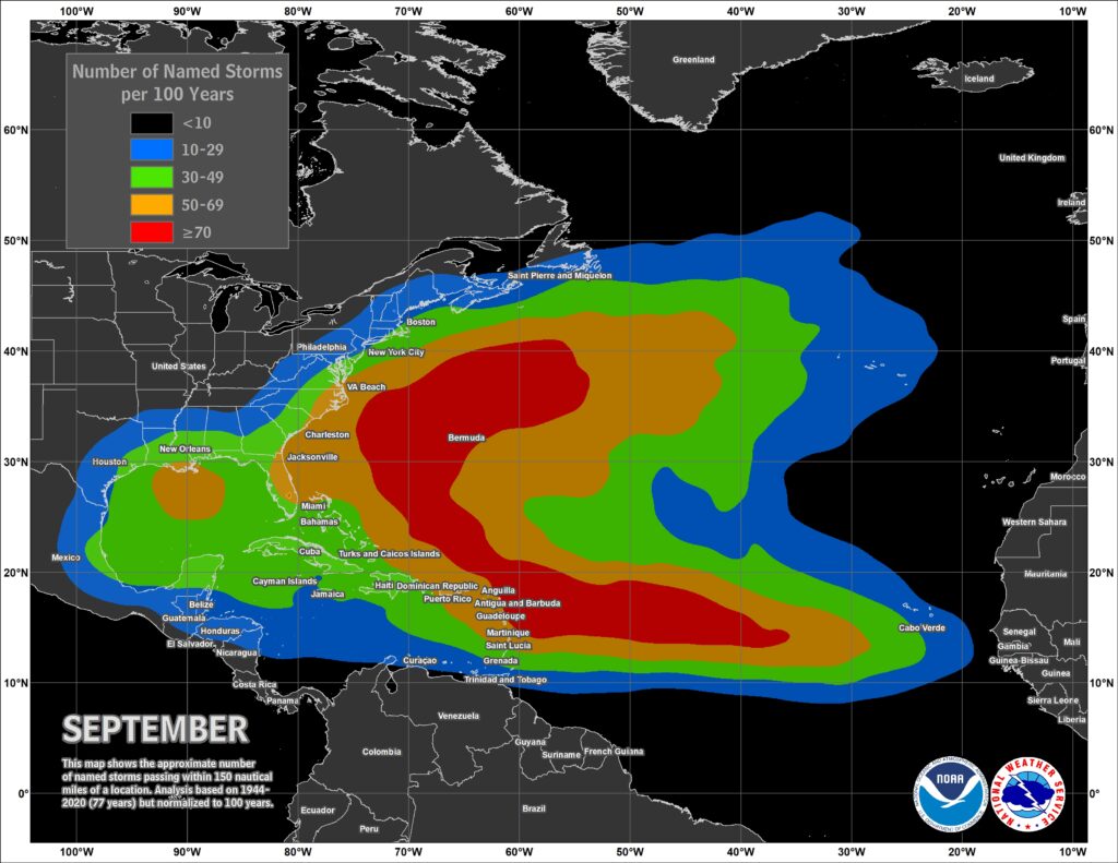
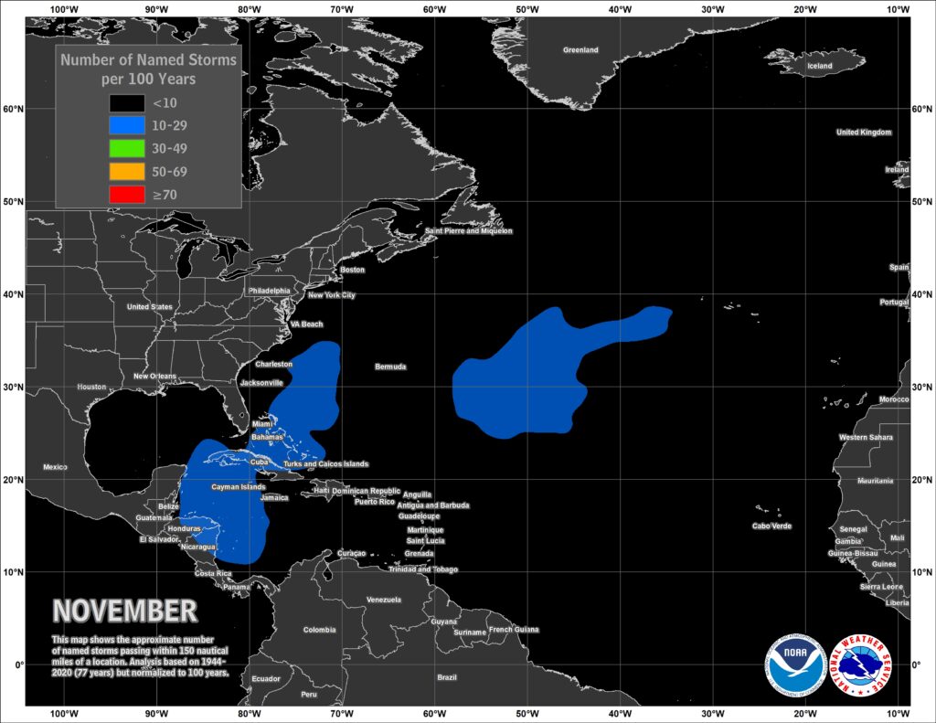
Historical occurrence areas for Atlantic named storms in June (left), September (middle), and November (right). Maps from NHC.
North Carolina’s Climatology
Our state’s unique geography adds to our susceptibility to tropical storms. Our coastline juts out several hundred miles compared to the land to our south, with a warm offshore ocean current called the Gulf Stream acting as an alleyway where strong storms can form and move. In addition, storms making landfall in the Gulf of Mexico can move northward, with their remnants affecting parts of western North Carolina.
Past analysis at our office identified historical tropical storms that affected North Carolina – including landfalling storms, remnant systems that moved over us, and storms that brought rain or other impacts to parts of the state – between 1851 and 2019.
We found a total of 387 storms that either made landfall or passed within 150 miles of our state, which was 19.3% of all Atlantic tropical storms during that 169-year period. That means 2.3 storms per year affect North Carolina, on average, with one storm every two years making direct landfall.
As with the overall Atlantic basin, the peak of the season between early September and mid-October is our most active period. However, we also see a secondary increase in activity in June and July associated with early-season storms forming over the warm water just off our coastline.
An overall active season in the Atlantic is no guarantee of an active season in North Carolina. If large-scale atmospheric patterns such as the Bermuda high pressure system are parked over us for much of the hurricane season, then those features can act as a roadblock and steer storms away from us. This was the case in 2023, when 20 total storms formed in the Atlantic basin but only 3 of them made landfall in the mainland US, including just one – Tropical Storm Ophelia – in North Carolina.
On the other hand, a quiet season with few named storms can still be an impactful and memorable one if even one of those storms affects us locally. For example, 1960 featured only six named storms, but among them, Hurricane Donna impacted Florida as a Category-4 and North Carolina as a still-damaging Category-2 hurricane.