Climate Change and Hurricanes
Hurricanes: Tropical Storm Science 🌀 Hazards 🌀 Notable Storms 🌀 Climate Change 🌀 Hurricanes Database 🌀 NC Landfalls
The characteristics of tropical storms, including their impacts in North Carolina, are changing as air and ocean temperatures warm and other atmospheric patterns evolve due to climate change. We’ve already seen some of those changes, such as the recent spate of freshwater flooding from storms beginning with Hurricane Floyd in 1999, and there are more changes on the horizon that will affect how hurricanes impact us.
Hurricane Intensity
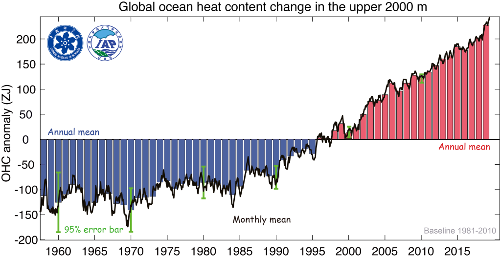
Because hurricanes derive their strength from warm water at the sea surface, changes in water temperatures boost the ultimate intensity of these storms. Globally, ocean heat content has steadily increased since the 1990s, including in the Caribbean, Gulf of Mexico, and the Gulf Stream off our coastline – all regions where tropical storms tend to form and track.
While some cyclical local patterns such as the Atlantic Multi-decadal Oscillation have also been in a warm phase over that time period, the brunt of the global ocean warming is closely tied to climate change, with a United Nations report reporting that “the ocean has absorbed around 90% of the heat generated by rising greenhouse gas emissions trapped in the Earth’s system.”
With warmer water available, especially in regions already favored for tropical storm activity, the North Carolina Climate Science Report notes that it’s likely – representing at least a two-in-three chance of occurring – that the intensity of the strongest hurricanes will continue to increase.
In addition, hurricanes are undergoing rapid intensification – defined as a maximum wind speed increase of at least 35 miles per hour in a 24-hour period – more often due to warmer ocean temperatures and more favorable environmental conditions such as lower wind shear. One study found an upward trend in intensification rates for storms off the US east coast between 1979 and 2018. Rapid hurricane intensification makes it more difficult to communicate the risk to the public in time for proactive action to be taken to protect lives and livelihoods.
Note that while there is high confidence in the overall intensification of the strongest hurricanes, there is lower confidence in whether the number of tropical storms or hurricanes will increase, and in whether the number of landfalling storms in North Carolina will change.
Impacts on Land
Storm Surge
When storms reach our shores, one common hazard we face is storm surge, when a wind-driven rush of water overtakes the coastline. These coastal areas have already become more vulnerable to storm damage due to background sea level rise, which amounts to almost a foot in the Wilmington area since 1950 and even more along our flatter northern coastline. The North Carolina Climate Science Report notes that it is “virtually certain that rising sea level and increasing intensity of coastal storms, especially hurricanes, will lead to increases in storm surge flooding in coastal North Carolina.”
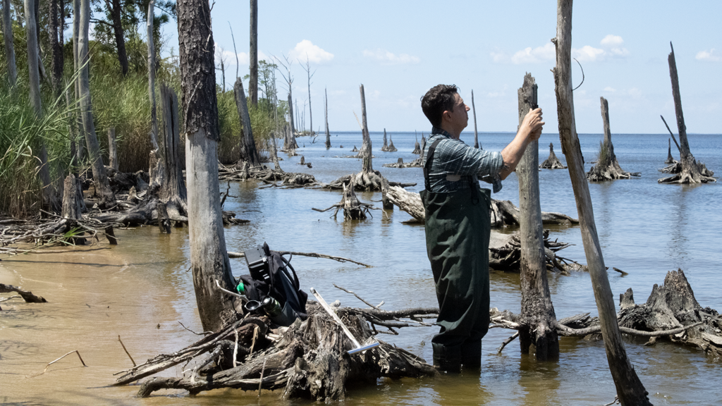
In addition, hurricanes accelerate the conversion of forested wetlands into ghost forests. This happens because sea level rise and storm surge increase the salt content of wetlands, and the trees, not adapted to this salty environment, begin to die. Researchers found that the rate of ghost forest formation in eastern North Carolina was greatest immediately after Hurricane Irene in 2011.
Heavy Rainfall
As these storms move over land, they unleash their moisture as rainfall, which can lead to its own array of hazards including freshwater flooding, landslides, and carrying harmful contaminants. And as our atmosphere warms, its capacity for water vapor also increases, making heavy rain events even heavier.
Per the North Carolina Climate Science Report, “heavy precipitation accompanying hurricanes is very likely to increase, increasing the potential for freshwater floods.” Adding to this hazard are the more frequent slowdowns and stalls these storms are making over land; north Atlantic storms slowed by about 16%, on average, over land areas between 1949 and 2016. This trend is likely related to weakening tropical circulation patterns that help move hurricanes around the world.
We’ve already seen the impact of such slowdowns, particularly during Hurricane Florence in 2018. Simulations of Florence under a possible future climate show its maximum rainfall increasing by almost 50%, while the land area receiving at least 30 inches of rain would more than triple.