Hurricane Hazards
Hurricanes: Tropical Storm Science 🌀 Hazards 🌀 Notable Storms 🌀 Climate Change 🌀 Hurricanes Database 🌀 NC Landfalls
When hurricanes or their remnants reach North Carolina, they can bring a wide range of impacts, often varying across the state from the shoreline to our high mountain slopes. With so many damaging conditions possible during these storms, that makes preparedness even more important.
Damaging Winds
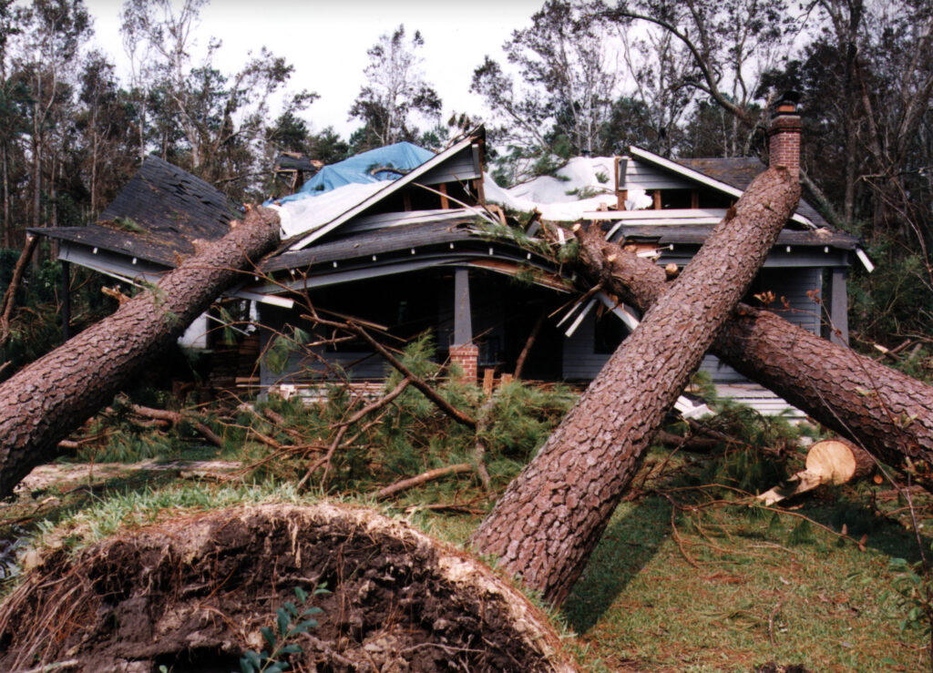
When you think about landfalling hurricanes, the image of flags being ripped and trees being tilted by the wind probably comes to mind. Indeed, hurricanes are well known for – and even classified by – their wind speeds, which by definition reach at least 74 miles per hour.
The winds of even a low-end hurricane or tropical storm are capable of damaging well-constructed homes, especially via falling branches or trees, which can also be caused by strong winds.
A storm’s strongest winds tend to occur in the eyewall since it’s near the area of the lowest pressure, and within the right front quadrant – that is, on the right side of the storm’s direction of movement – since the storm’s forward speed adds to the effective force of the winds.
After making landfall, a tropical storm’s winds tend to weaken due the increased friction of the rough land surface, but strong storms can still produce damaging winds well inland. Major hurricanes at landfall such as Hazel, Hugo, and Fran each generated hurricane-force wind gusts in areas such as Raleigh, Charlotte, and Fayetteville.
Storm Surge
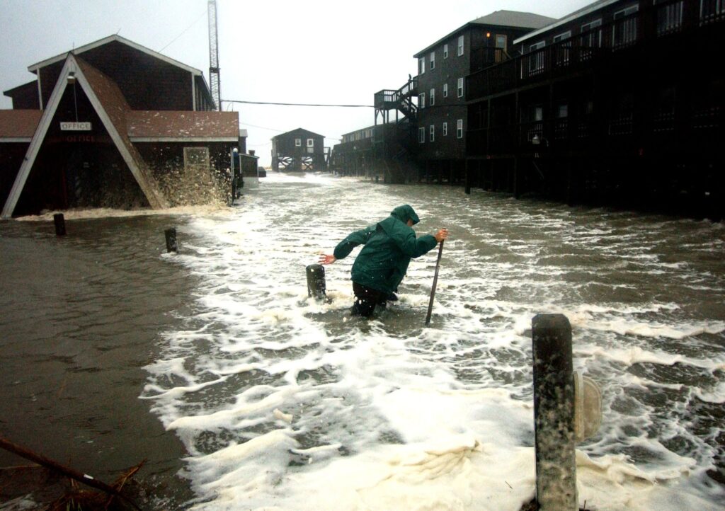
While at sea, a storm’s winds will whip up the ocean surface and produce some monstrous waves that we can see as high surf, even when a storm is hundreds of miles offshore. Once a storm reaches our coastline, those same wind-driven waves become an even more potent hazard called the storm surge, when the ocean overtakes our low-lying coastal areas.
The surge is typically highest to the right of the eye due to the same right front quadrant effect that produces higher winds in those areas. For instance, when Hurricane Hazel made landfall along the North Carolina/South Carolina border, the highest surge of 18 feet occurred just east of there in Calabash.
Complexities of our coastline shape can also lead to a high storm surge in some unexpected areas. If storms cross over or parallel the Outer Banks, their counterclockwise winds can push water from the Pamlico Sound up against inland-facing parts of the coastline; this is called a soundside storm surge, and it was particularly impactful during Hurricane Dorian in 2019 in towns such as Oriental and Ocracoke.
Heavy Rain
As part of their formation at sea, tropical storms are loaded with moisture, and when a storm hundreds of miles in diameter moves over North Carolina, it can drop this moisture as some heavy rainfall amounts.
In our most extreme cases, hurricanes have produced local totals of more than 24 inches of rain. This occurred during Hurricane Floyd in 1999 (24.06 inches in Southport), during Hurricane Florence in 2018 (35.93 inches in Elizabethtown), and Hurricane Helene in 2024 (31.33 inches in Busick).
While receiving this much rain over the course of just a few hours or days can lead to other impacts such as flooding and landslides, it’s important to remember that hurricanes and their rainfall contribution are a part of our climate. Past research at our office showed that for some coastal areas, tropical storms are responsible for up to 20% of the total rainfall during the summer and fall.
That means that when we miss out on rainfall from these storms, we can see droughts develop, and likewise, soaking rains from a hurricane – preferably without the flooding consequences – are one of our most effective drought busters.
Freshwater Flooding
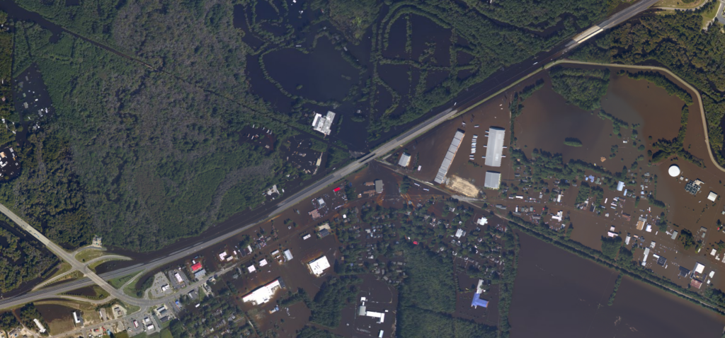
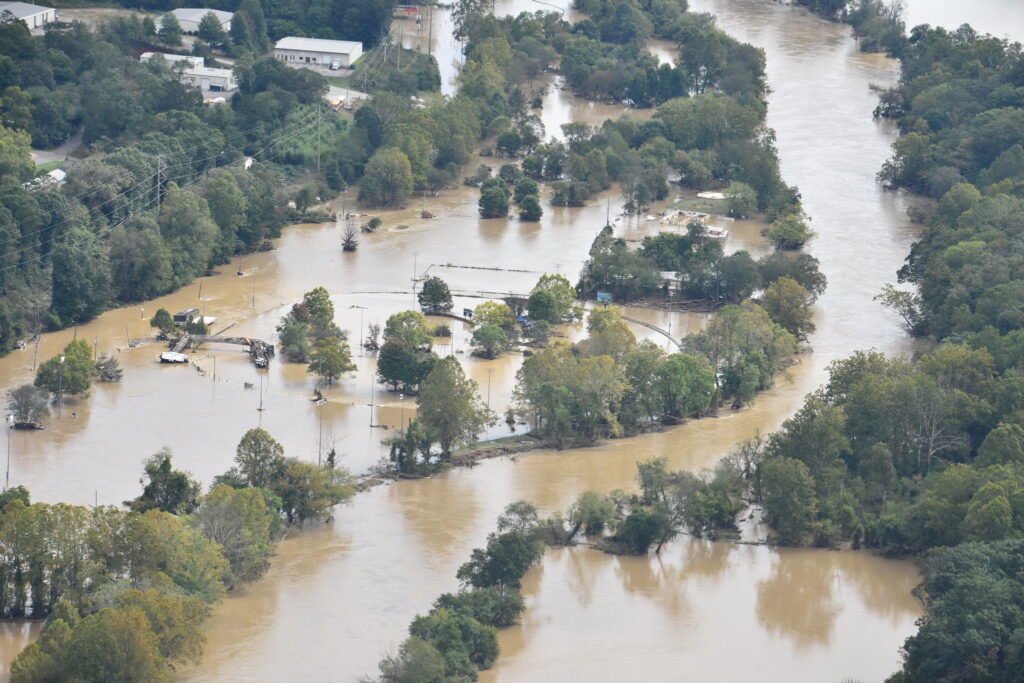
When torrential rain falls from a tropical storm, all of that water has to go somewhere, and it typically ends up in streams and rivers. When those channels are full, that water then spills over onto the surrounding landscape, flooding agricultural fields, roadways, and nearby cities and towns.
After being historically unheard of on a broad scale, we’ve had four storms produce significant freshwater flooding since 1999: Floyd, Matthew, Florence, and Helene. Each caused record rainfall amounts, record river crests, and a number of deaths due to the flooding.
That trend holds true nationwide, as 57% of deaths associated with landfalling tropical storms between 2013 and 2022 were due to freshwater flooding. Along with being deadly, these flooding storms are among our most costly due to the extent and difficulty of cleaning up water damage in homes and communities.
Freshwater flooding, including from hurricanes, is becoming more common due to climate change since a warmer atmosphere means more moisture available for storms.
Landslides
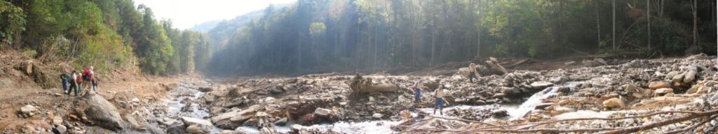
In addition to flooding, another side effect of heavy rain across the landscape is landslides. These occur when moisture weakens the soil on mountain slopes and it is pulled downward by gravity. When these slides pick up materials such as rocks, cars, and even homes, they’re called debris flows, and they can travel at great speeds and over long distances.
In western North Carolina, landslides have been most common when multiple remnant tropical systems have moved through just days or weeks apart, since each event further saturates and weakens the ground.
In August 1940, the second soaking rain event in the span of one week produced flooding throughout the Mountains and more than 2,000 landslides in Watauga County. And in September 2004, Hurricane Ivan followed in Frances’ tracks, triggering a number of landslides in the southern Mountains, including the deadly Peeks Creek debris flow in Macon County.
Severe Weather
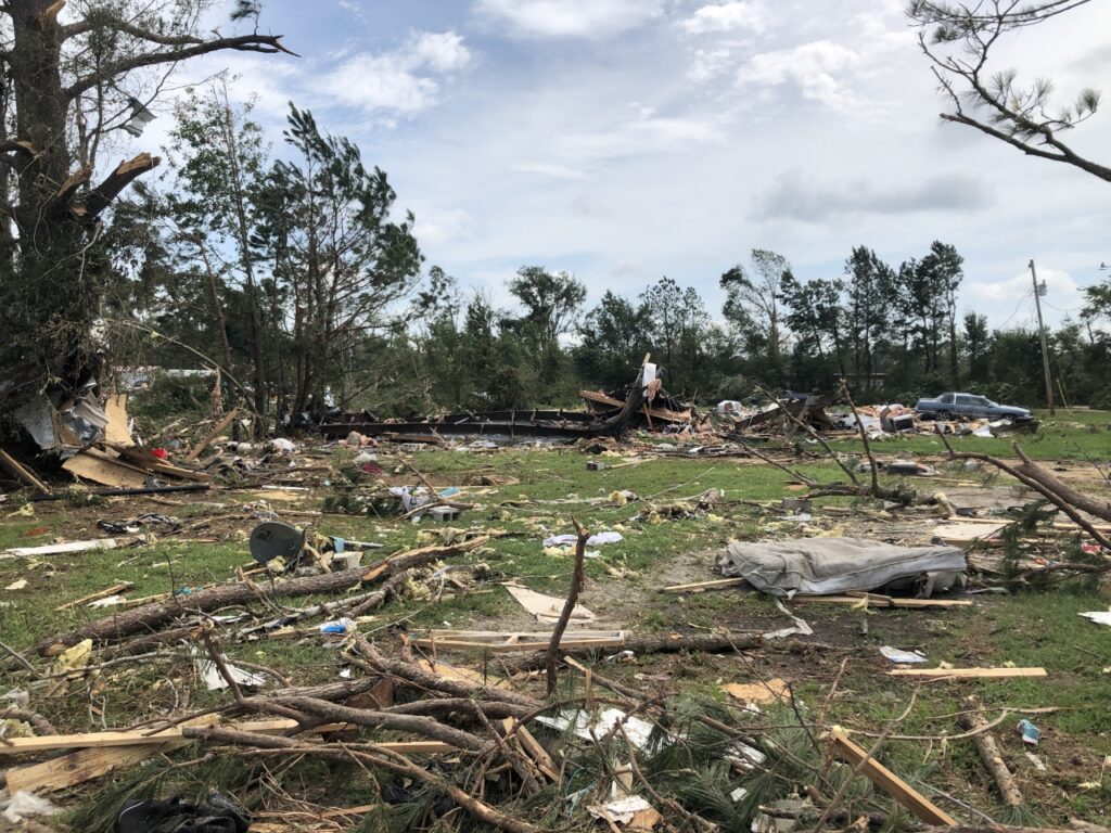
Thunderstorms are the building blocks of hurricanes, which severe thunderstorm hazards are possible during our tropical events, most commonly when the outer rain bands move over North Carolina.
Embedded thunderstorms in these rain bands have access to ample moisture, instability, lift, and the shifting, shearing winds that creates an overturning of air in the lower atmosphere; these are all ingredients for tornado formation, which occurs when that spiraling air is tilted vertically by a thunderstorm updraft.
While most tropical tornadoes tend to be weaker and short-lived, they can still be damaging or deadly, and on occasion, stronger tornadoes are possible. In 2020, Hurricane Isaias spawned an EF3 tornado that injured 14 people and killed 2 in Bertie County. And in 2024, Hurricane Helene spawned an EF3 in Nash County that occurred almost 400 miles from the storm’s center at the time.
Compound Hazards
The combination of these hazards that we tend to get with most tropical storms, as well as their interactions with our human-built infrastructure, can lead to additional, compound events. Examples of these in North Carolina include:
- Power outages due to heavy rain weakening the ground around tree roots and gusty winds blowing those trees across power lines. In an extreme case, Hurricane Fran knocked out power to 1.7 million electrical customers across the state.
- Coastal erosion can occur at an accelerated rate due to the wind-driven water and storm surge from hurricanes, exacerbating background changes in our shoreline caused by ocean currents and sea level rise. Storms such as Isabel in 2003 and Irene in 2011 have cut new inlets along the Outer Banks.
- Wildfire danger can increase in the wake of storms that toppled many trees, which leaves that dead debris behind and ready to burn. This has been a notable long-term impact after 2024’s Hurricane Helene, with 822,000 acres of timberland damaged on rugged terrain that began burning during the drought-plagued winter of 2024-25.
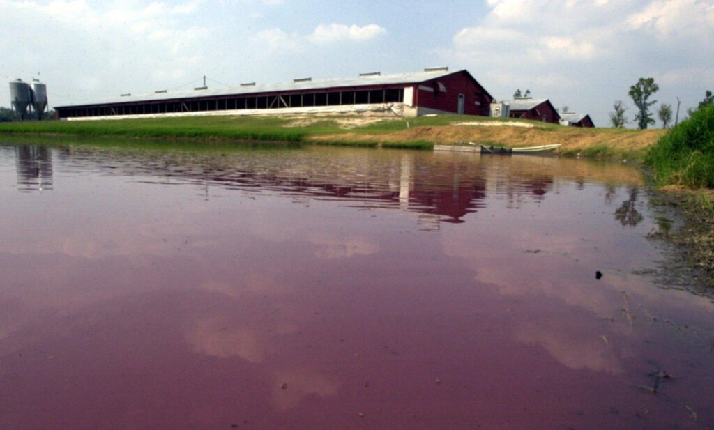
- Health risks can emerge immediately after storms for a number of reasons, including physical injuries from falling debris, a proliferation of disease-carrying mosquitoes in flooded areas, and the infiltration of contaminants into drinking water, such as the agricultural waste following Hurricane Floyd and more than 100,000 gallons of petroleum spilling in the French Broad River basin after Frances and Ivan in 2004.
Safety and Preparedness
Hurricanes are among our costliest natural disasters, and they can have widespread impacts on lives and property. No matter where you live across the state, it’s important to prepare for potential hurricane hazards and be ready to respond if and when these events occur. The following tips can help you prepare and stay safe during a storm:
- Prepare a disaster kit. Assembling supplies, files, and a family plan ahead of time can help you be ready to act if a storm strikes. See more about supplies for a household disaster kit, documents and valuables to safeguard, home preparedness tips, and the NC DHHS Family Disaster Plan.
- Know your flood risk. Whether you’re at the coast or inland, check whether you’re in a flood-prone area using the FEMA Flood Map Service Center and study their safety tips for before, during, and after a flood.
- Find your evacuation route. Coastal residents may need to evacuate when storms threaten our state with surge and flooding. North Carolina uses a tiered evacuation system for 21 coastal counties, which you can explore, along with FAQs and a hurricane guide, on the Department of Public Safety’s website.
- Be safe and informed during storms. If a storm is bearing down on your and your home, make sure you have a way to receive emergency alerts via your phone or a weather radio and know safe spaces to shelter.
- Take care during cleanup. Whether you’re returning home or surveying and fixing damage, use caution after storms, know how to file a flood insurance claim, and be mindful of mental health in the wake of a disaster.
For more preparedness information, explore recommendations from FEMA, NOAA, and NC DHHS.